You are here: Home > Network List > TA - USArray Transportable Network (new EarthScope stations) Stations List
> Station H53A Bobcaygeon, ON, CAN > Earthquake Result Viewer
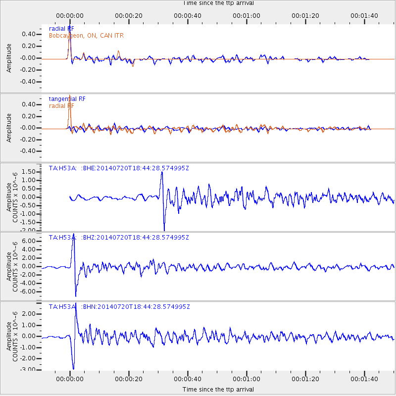
H53A Bobcaygeon, ON, CAN - Earthquake Result Viewer

| Earthquake location: |
Kuril Islands |
| Earthquake latitude/longitude: |
44.6/148.7 |
| Earthquake time(UTC): |
2014/07/20 (201) 18:32:47 GMT |
| Earthquake Depth: |
61 km |
| Earthquake Magnitude: |
6.6 MB |
| Earthquake Catalog/Contributor: |
NEIC PDE/NEIC COMCAT |
|
| Network: |
TA USArray Transportable Network (new EarthScope stations) |
| Station: |
H53A Bobcaygeon, ON, CAN |
| Lat/Lon: |
44.57 N/78.58 W |
| Elevation: |
292 m |
|
| Distance: |
81.7 deg |
| Az: |
32.062 deg |
| Baz: |
327.969 deg |
| Ray Param: |
0.047255967 |
| Estimated Moho Depth: |
41.75 km |
| Estimated Crust Vp/Vs: |
1.72 |
| Assumed Crust Vp: |
6.577 km/s |
| Estimated Crust Vs: |
3.835 km/s |
| Estimated Crust Poisson's Ratio: |
0.24 |
|
| Radial Match: |
94.29524 % |
| Radial Bump: |
304 |
| Transverse Match: |
75.60528 % |
| Transverse Bump: |
400 |
| SOD ConfigId: |
751272 |
| Insert Time: |
2014-08-04 16:11:48.646 +0000 |
| GWidth: |
2.5 |
| Max Bumps: |
400 |
| Tol: |
0.001 |
|
Signal To Noise
| Channel | StoN | STA | LTA |
| TA:H53A: :BHZ:20140720T18:44:28.574995Z | 22.737143 | 3.4675782E-6 | 1.525072E-7 |
| TA:H53A: :BHN:20140720T18:44:28.574995Z | 16.551712 | 1.3209544E-6 | 7.980772E-8 |
| TA:H53A: :BHE:20140720T18:44:28.574995Z | 8.461944 | 7.7952075E-7 | 9.212077E-8 |
| Arrivals |
| Ps | 4.7 SECOND |
| PpPs | 17 SECOND |
| PsPs/PpSs | 21 SECOND |


