You are here: Home > Network List > TA - USArray Transportable Network (new EarthScope stations) Stations List
> Station H57A Richville, NY, USA > Earthquake Result Viewer
H57A Richville, NY, USA - Earthquake Result Viewer
| Earthquake location: |
Kuril Islands |
| Earthquake latitude/longitude: |
44.6/148.7 |
| Earthquake time(UTC): |
2014/07/20 (201) 18:32:47 GMT |
| Earthquake Depth: |
61 km |
| Earthquake Magnitude: |
6.6 MB |
| Earthquake Catalog/Contributor: |
NEIC PDE/NEIC COMCAT |
|
| Network: |
TA USArray Transportable Network (new EarthScope stations) |
| Station: |
H57A Richville, NY, USA |
| Lat/Lon: |
44.46 N/75.39 W |
| Elevation: |
132 m |
|
| Distance: |
83.0 deg |
| Az: |
30.146 deg |
| Baz: |
329.946 deg |
| Ray Param: |
0.046372995 |
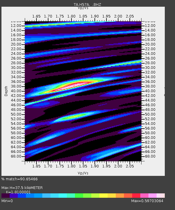
| Estimated Moho Depth: |
37.5 km |
| Estimated Crust Vp/Vs: |
1.81 |
| Assumed Crust Vp: |
6.419 km/s |
| Estimated Crust Vs: |
3.547 km/s |
| Estimated Crust Poisson's Ratio: |
0.28 |
|
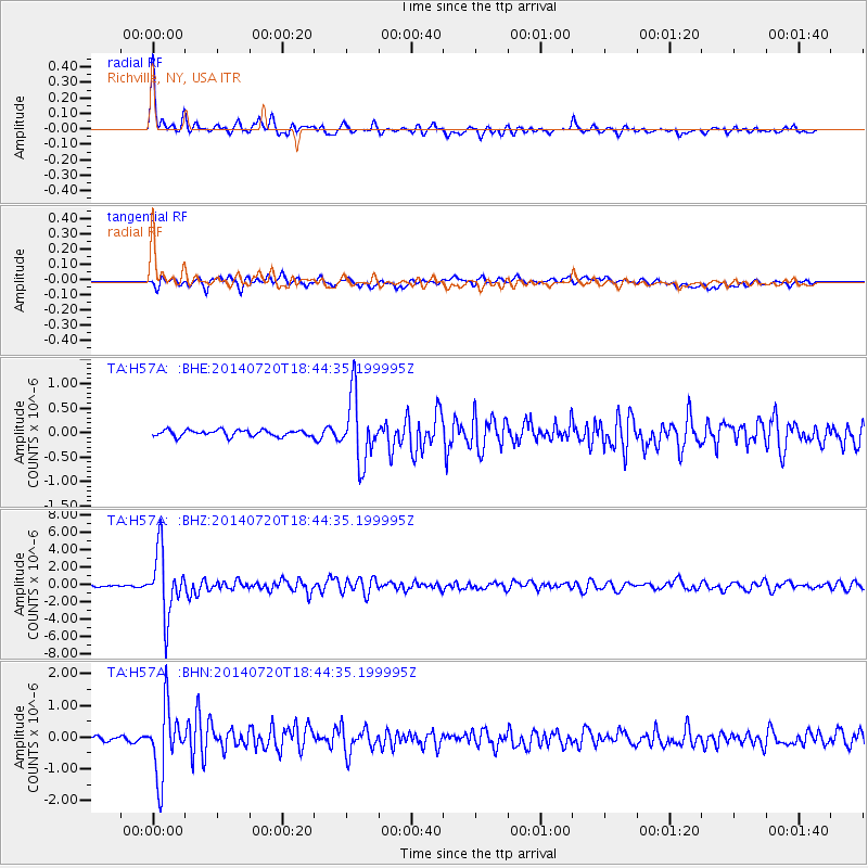
| Radial Match: |
90.65466 % |
| Radial Bump: |
400 |
| Transverse Match: |
74.686935 % |
| Transverse Bump: |
400 |
| SOD ConfigId: |
751272 |
| Insert Time: |
2014-08-04 16:11:58.126 +0000 |
| GWidth: |
2.5 |
| Max Bumps: |
400 |
| Tol: |
0.001 |
|
Signal To Noise
| Channel | StoN | STA | LTA |
| TA:H57A: :BHZ:20140720T18:44:35.199995Z | 29.05894 | 3.603329E-6 | 1.240007E-7 |
| TA:H57A: :BHN:20140720T18:44:35.199995Z | 14.342365 | 1.0676736E-6 | 7.444195E-8 |
| TA:H57A: :BHE:20140720T18:44:35.199995Z | 10.407746 | 6.6552974E-7 | 6.394561E-8 |
| Arrivals |
| Ps | 4.9 SECOND |
| PpPs | 16 SECOND |
| PsPs/PpSs | 21 SECOND |


