You are here: Home > Network List > CN - Canadian National Seismograph Network Stations List
> Station INK INUVIK, NT > Earthquake Result Viewer
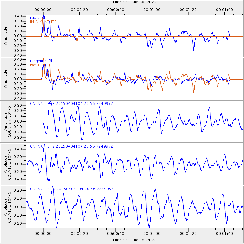
INK INUVIK, NT - Earthquake Result Viewer
*The percent match for this event was below the threshold and hence no stack was calculated.
| Earthquake location: |
New Britain Region, P.N.G. |
| Earthquake latitude/longitude: |
-5.4/152.9 |
| Earthquake time(UTC): |
2015/04/04 (094) 04:08:35 GMT |
| Earthquake Depth: |
22 km |
| Earthquake Magnitude: |
5.3 MW |
| Earthquake Catalog/Contributor: |
ISC/ISC |
|
| Network: |
CN Canadian National Seismograph Network |
| Station: |
INK INUVIK, NT |
| Lat/Lon: |
68.31 N/133.53 W |
| Elevation: |
44 m |
|
| Distance: |
89.0 deg |
| Az: |
20.898 deg |
| Baz: |
252.788 deg |
| Ray Param: |
$rayparam |
*The percent match for this event was below the threshold and hence was not used in the summary stack. |
|
| Radial Match: |
46.752167 % |
| Radial Bump: |
400 |
| Transverse Match: |
72.29668 % |
| Transverse Bump: |
400 |
| SOD ConfigId: |
7422571 |
| Insert Time: |
2019-04-18 02:19:47.231 +0000 |
| GWidth: |
2.5 |
| Max Bumps: |
400 |
| Tol: |
0.001 |
|
Signal To Noise
| Channel | StoN | STA | LTA |
| CN:INK: :BHZ:20150404T04:20:56.724995Z | 3.2369025 | 3.1929088E-7 | 9.864087E-8 |
| CN:INK: :BHN:20150404T04:20:56.724995Z | 1.9358443 | 1.1703129E-7 | 6.045491E-8 |
| CN:INK: :BHE:20150404T04:20:56.724995Z | 0.72447884 | 1.3890615E-7 | 1.9173251E-7 |
| Arrivals |
| Ps | |
| PpPs | |
| PsPs/PpSs | |


