You are here: Home > Network List > TA - USArray Transportable Network (new EarthScope stations) Stations List
> Station H62A Milan, NH, USA > Earthquake Result Viewer
H62A Milan, NH, USA - Earthquake Result Viewer
| Earthquake location: |
Kuril Islands |
| Earthquake latitude/longitude: |
44.6/148.7 |
| Earthquake time(UTC): |
2014/07/20 (201) 18:32:47 GMT |
| Earthquake Depth: |
61 km |
| Earthquake Magnitude: |
6.6 MB |
| Earthquake Catalog/Contributor: |
NEIC PDE/NEIC COMCAT |
|
| Network: |
TA USArray Transportable Network (new EarthScope stations) |
| Station: |
H62A Milan, NH, USA |
| Lat/Lon: |
44.57 N/71.16 W |
| Elevation: |
381 m |
|
| Distance: |
84.4 deg |
| Az: |
27.42 deg |
| Baz: |
332.606 deg |
| Ray Param: |
0.0454155 |
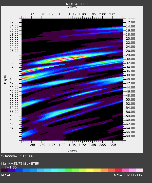
| Estimated Moho Depth: |
35.75 km |
| Estimated Crust Vp/Vs: |
1.65 |
| Assumed Crust Vp: |
6.419 km/s |
| Estimated Crust Vs: |
3.89 km/s |
| Estimated Crust Poisson's Ratio: |
0.21 |
|
| Radial Match: |
96.15844 % |
| Radial Bump: |
331 |
| Transverse Match: |
91.26334 % |
| Transverse Bump: |
400 |
| SOD ConfigId: |
751272 |
| Insert Time: |
2014-08-04 16:12:21.153 +0000 |
| GWidth: |
2.5 |
| Max Bumps: |
400 |
| Tol: |
0.001 |
|

Signal To Noise
| Channel | StoN | STA | LTA |
| TA:H62A: :BHZ:20140720T18:44:42.10002Z | 63.50002 | 6.0714033E-6 | 9.561263E-8 |
| TA:H62A: :BHN:20140720T18:44:42.10002Z | 24.032776 | 3.0028796E-6 | 1.2494934E-7 |
| TA:H62A: :BHE:20140720T18:44:42.10002Z | 10.790232 | 1.1887795E-6 | 1.1017181E-7 |
| Arrivals |
| Ps | 3.7 SECOND |
| PpPs | 14 SECOND |
| PsPs/PpSs | 18 SECOND |


