You are here: Home > Network List > TA - USArray Transportable Network (new EarthScope stations) Stations List
> Station H63A New Sharon, ME, USA > Earthquake Result Viewer
H63A New Sharon, ME, USA - Earthquake Result Viewer
| Earthquake location: |
Kuril Islands |
| Earthquake latitude/longitude: |
44.6/148.7 |
| Earthquake time(UTC): |
2014/07/20 (201) 18:32:47 GMT |
| Earthquake Depth: |
61 km |
| Earthquake Magnitude: |
6.6 MB |
| Earthquake Catalog/Contributor: |
NEIC PDE/NEIC COMCAT |
|
| Network: |
TA USArray Transportable Network (new EarthScope stations) |
| Station: |
H63A New Sharon, ME, USA |
| Lat/Lon: |
44.66 N/70.04 W |
| Elevation: |
109 m |
|
| Distance: |
84.7 deg |
| Az: |
26.664 deg |
| Baz: |
333.319 deg |
| Ray Param: |
0.045210425 |
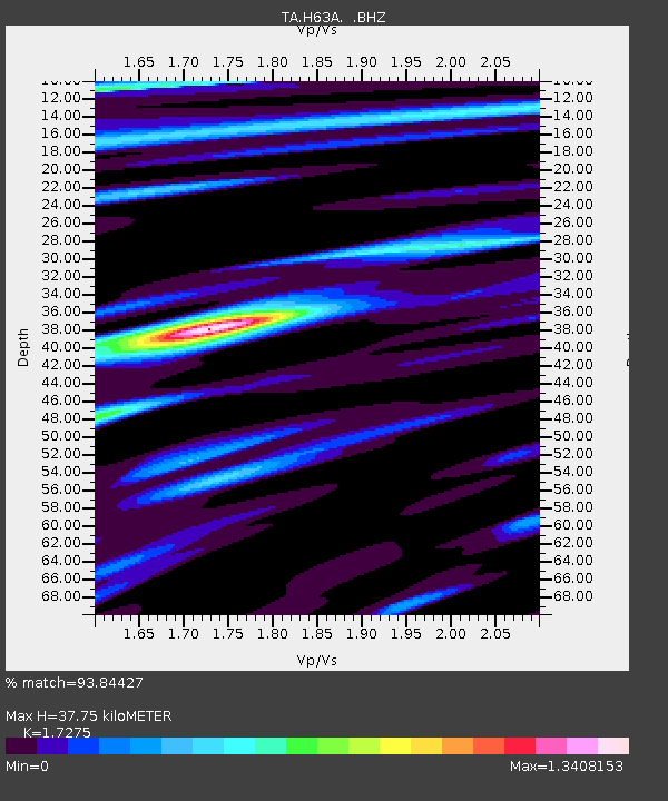
| Estimated Moho Depth: |
37.75 km |
| Estimated Crust Vp/Vs: |
1.73 |
| Assumed Crust Vp: |
6.419 km/s |
| Estimated Crust Vs: |
3.716 km/s |
| Estimated Crust Poisson's Ratio: |
0.25 |
|
| Radial Match: |
93.84427 % |
| Radial Bump: |
400 |
| Transverse Match: |
90.41612 % |
| Transverse Bump: |
342 |
| SOD ConfigId: |
751272 |
| Insert Time: |
2014-08-04 16:12:21.457 +0000 |
| GWidth: |
2.5 |
| Max Bumps: |
400 |
| Tol: |
0.001 |
|

Signal To Noise
| Channel | StoN | STA | LTA |
| TA:H63A: :BHZ:20140720T18:44:43.549971Z | 40.424377 | 6.0630273E-6 | 1.4998443E-7 |
| TA:H63A: :BHN:20140720T18:44:43.549971Z | 14.633249 | 1.993179E-6 | 1.3620891E-7 |
| TA:H63A: :BHE:20140720T18:44:43.549971Z | 6.822636 | 1.0563418E-6 | 1.5482898E-7 |
| Arrivals |
| Ps | 4.4 SECOND |
| PpPs | 16 SECOND |
| PsPs/PpSs | 20 SECOND |


