You are here: Home > Network List > CI - Caltech Regional Seismic Network Stations List
> Station NEE Needles, California, USA > Earthquake Result Viewer
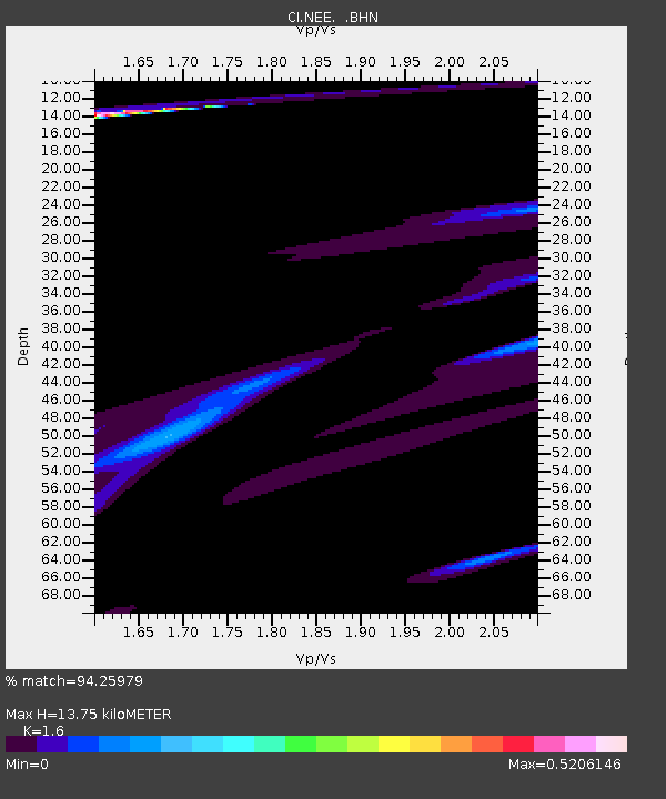
NEE Needles, California, USA - Earthquake Result Viewer
| Earthquake location: |
Kodiak Island Region, Alaska |
| Earthquake latitude/longitude: |
57.4/-154.4 |
| Earthquake time(UTC): |
1999/12/06 (340) 23:22:55 GMT |
| Earthquake Depth: |
50 km |
| Earthquake Magnitude: |
5.6 MB, 5.5 ML, 5.4 ML |
| Earthquake Catalog/Contributor: |
WHDF/NEIC |
|
| Network: |
CI Caltech Regional Seismic Network |
| Station: |
NEE Needles, California, USA |
| Lat/Lon: |
34.82 N/114.60 W |
| Elevation: |
139 m |
|
| Distance: |
34.9 deg |
| Az: |
112.964 deg |
| Baz: |
322.665 deg |
| Ray Param: |
0.077388965 |
| Estimated Moho Depth: |
13.75 km |
| Estimated Crust Vp/Vs: |
1.60 |
| Assumed Crust Vp: |
6.276 km/s |
| Estimated Crust Vs: |
3.922 km/s |
| Estimated Crust Poisson's Ratio: |
0.18 |
|
| Radial Match: |
94.25979 % |
| Radial Bump: |
400 |
| Transverse Match: |
28.313677 % |
| Transverse Bump: |
400 |
| SOD ConfigId: |
3770 |
| Insert Time: |
2010-02-25 21:12:38.293 +0000 |
| GWidth: |
2.5 |
| Max Bumps: |
400 |
| Tol: |
0.001 |
|

Signal To Noise
| Channel | StoN | STA | LTA |
| CI:NEE: :BHN:19991206T23:29:11.936008Z | 1.7941302 | 3.2337615E-5 | 1.8024119E-5 |
| CI:NEE: :BHE:19991206T23:29:11.936008Z | 1.89959 | 1.6464805E-5 | 8.667557E-6 |
| CI:NEE: :BHZ:19991206T23:29:11.936008Z | 5.125629 | 2.8787816E-5 | 5.6164454E-6 |
| Arrivals |
| Ps | 1.4 SECOND |
| PpPs | 5.3 SECOND |
| PsPs/PpSs | 6.7 SECOND |


