You are here: Home > Network List > TA - USArray Transportable Network (new EarthScope stations) Stations List
> Station J56A Wolcott, NY, USA > Earthquake Result Viewer
J56A Wolcott, NY, USA - Earthquake Result Viewer
| Earthquake location: |
Kuril Islands |
| Earthquake latitude/longitude: |
44.6/148.7 |
| Earthquake time(UTC): |
2014/07/20 (201) 18:32:47 GMT |
| Earthquake Depth: |
61 km |
| Earthquake Magnitude: |
6.6 MB |
| Earthquake Catalog/Contributor: |
NEIC PDE/NEIC COMCAT |
|
| Network: |
TA USArray Transportable Network (new EarthScope stations) |
| Station: |
J56A Wolcott, NY, USA |
| Lat/Lon: |
43.28 N/76.86 W |
| Elevation: |
93 m |
|
| Distance: |
83.5 deg |
| Az: |
31.673 deg |
| Baz: |
329.112 deg |
| Ray Param: |
0.046029624 |
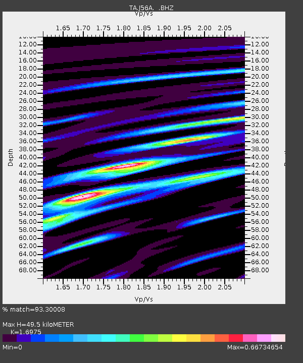
| Estimated Moho Depth: |
49.5 km |
| Estimated Crust Vp/Vs: |
1.70 |
| Assumed Crust Vp: |
6.476 km/s |
| Estimated Crust Vs: |
3.815 km/s |
| Estimated Crust Poisson's Ratio: |
0.23 |
|
| Radial Match: |
93.30008 % |
| Radial Bump: |
391 |
| Transverse Match: |
84.716606 % |
| Transverse Bump: |
400 |
| SOD ConfigId: |
751272 |
| Insert Time: |
2014-08-04 16:14:12.995 +0000 |
| GWidth: |
2.5 |
| Max Bumps: |
400 |
| Tol: |
0.001 |
|

Signal To Noise
| Channel | StoN | STA | LTA |
| TA:J56A: :BHZ:20140720T18:44:37.674971Z | 32.259323 | 3.3133526E-6 | 1.02709926E-7 |
| TA:J56A: :BHN:20140720T18:44:37.674971Z | 14.194626 | 1.2893097E-6 | 9.083084E-8 |
| TA:J56A: :BHE:20140720T18:44:37.674971Z | 9.740073 | 8.0994175E-7 | 8.315561E-8 |
| Arrivals |
| Ps | 5.5 SECOND |
| PpPs | 20 SECOND |
| PsPs/PpSs | 26 SECOND |


