You are here: Home > Network List > TA - USArray Transportable Network (new EarthScope stations) Stations List
> Station J58A Remsen, NY, USA > Earthquake Result Viewer
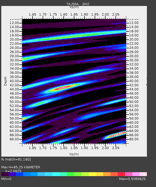
J58A Remsen, NY, USA - Earthquake Result Viewer
| Earthquake location: |
Kuril Islands |
| Earthquake latitude/longitude: |
44.6/148.7 |
| Earthquake time(UTC): |
2014/07/20 (201) 18:32:47 GMT |
| Earthquake Depth: |
61 km |
| Earthquake Magnitude: |
6.6 MB |
| Earthquake Catalog/Contributor: |
NEIC PDE/NEIC COMCAT |
|
| Network: |
TA USArray Transportable Network (new EarthScope stations) |
| Station: |
J58A Remsen, NY, USA |
| Lat/Lon: |
43.36 N/75.29 W |
| Elevation: |
436 m |
|
| Distance: |
84.0 deg |
| Az: |
30.634 deg |
| Baz: |
330.074 deg |
| Ray Param: |
0.045673076 |
| Estimated Moho Depth: |
65.25 km |
| Estimated Crust Vp/Vs: |
2.06 |
| Assumed Crust Vp: |
6.419 km/s |
| Estimated Crust Vs: |
3.112 km/s |
| Estimated Crust Poisson's Ratio: |
0.35 |
|
| Radial Match: |
91.1601 % |
| Radial Bump: |
345 |
| Transverse Match: |
84.17004 % |
| Transverse Bump: |
400 |
| SOD ConfigId: |
751272 |
| Insert Time: |
2014-08-04 16:14:21.480 +0000 |
| GWidth: |
2.5 |
| Max Bumps: |
400 |
| Tol: |
0.001 |
|

Signal To Noise
| Channel | StoN | STA | LTA |
| TA:J58A: :BHZ:20140720T18:44:40.249983Z | 27.589546 | 3.666232E-6 | 1.3288484E-7 |
| TA:J58A: :BHN:20140720T18:44:40.249983Z | 16.88016 | 1.3096221E-6 | 7.7583515E-8 |
| TA:J58A: :BHE:20140720T18:44:40.249983Z | 7.1720185 | 7.379173E-7 | 1.0288837E-7 |
| Arrivals |
| Ps | 11 SECOND |
| PpPs | 30 SECOND |
| PsPs/PpSs | 42 SECOND |


