You are here: Home > Network List > NN - Western Great Basin/Eastern Sierra Nevada Stations List
> Station GWY Greenwater Valley, CA. (GPS 12/06/2000) w84gm > Earthquake Result Viewer
GWY Greenwater Valley, CA. (GPS 12/06/2000) w84gm - Earthquake Result Viewer
| Earthquake location: |
New Britain Region, P.N.G. |
| Earthquake latitude/longitude: |
-5.4/152.9 |
| Earthquake time(UTC): |
2015/04/04 (094) 04:08:35 GMT |
| Earthquake Depth: |
22 km |
| Earthquake Magnitude: |
5.3 MW |
| Earthquake Catalog/Contributor: |
ISC/ISC |
|
| Network: |
NN Western Great Basin/Eastern Sierra Nevada |
| Station: |
GWY Greenwater Valley, CA. (GPS 12/06/2000) w84gm |
| Lat/Lon: |
36.19 N/116.67 W |
| Elevation: |
1538 m |
|
| Distance: |
93.5 deg |
| Az: |
54.143 deg |
| Baz: |
265.919 deg |
| Ray Param: |
0.041241977 |
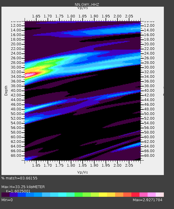
| Estimated Moho Depth: |
33.25 km |
| Estimated Crust Vp/Vs: |
1.60 |
| Assumed Crust Vp: |
6.279 km/s |
| Estimated Crust Vs: |
3.918 km/s |
| Estimated Crust Poisson's Ratio: |
0.18 |
|
| Radial Match: |
83.66155 % |
| Radial Bump: |
400 |
| Transverse Match: |
65.08396 % |
| Transverse Bump: |
282 |
| SOD ConfigId: |
7422571 |
| Insert Time: |
2019-04-18 02:20:49.400 +0000 |
| GWidth: |
2.5 |
| Max Bumps: |
400 |
| Tol: |
0.001 |
|

Signal To Noise
| Channel | StoN | STA | LTA |
| NN:GWY: :HHZ:20150404T04:21:17.62801Z | 1.0777725 | 2.100558E-7 | 1.9489809E-7 |
| NN:GWY: :HHN:20150404T04:21:17.62801Z | 1.0928954 | 2.7718656E-7 | 2.5362587E-7 |
| NN:GWY: :HHE:20150404T04:21:17.62801Z | 0.36306822 | 1.055768E-7 | 2.9079052E-7 |
| Arrivals |
| Ps | 3.3 SECOND |
| PpPs | 13 SECOND |
| PsPs/PpSs | 17 SECOND |


