You are here: Home > Network List > TA - USArray Transportable Network (new EarthScope stations) Stations List
> Station K02D Willamette Meridian, OR, USA > Earthquake Result Viewer
K02D Willamette Meridian, OR, USA - Earthquake Result Viewer
| Earthquake location: |
Kuril Islands |
| Earthquake latitude/longitude: |
44.6/148.7 |
| Earthquake time(UTC): |
2014/07/20 (201) 18:32:47 GMT |
| Earthquake Depth: |
61 km |
| Earthquake Magnitude: |
6.6 MB |
| Earthquake Catalog/Contributor: |
NEIC PDE/NEIC COMCAT |
|
| Network: |
TA USArray Transportable Network (new EarthScope stations) |
| Station: |
K02D Willamette Meridian, OR, USA |
| Lat/Lon: |
42.70 N/123.67 W |
| Elevation: |
989 m |
|
| Distance: |
60.3 deg |
| Az: |
57.965 deg |
| Baz: |
304.806 deg |
| Ray Param: |
0.061452188 |
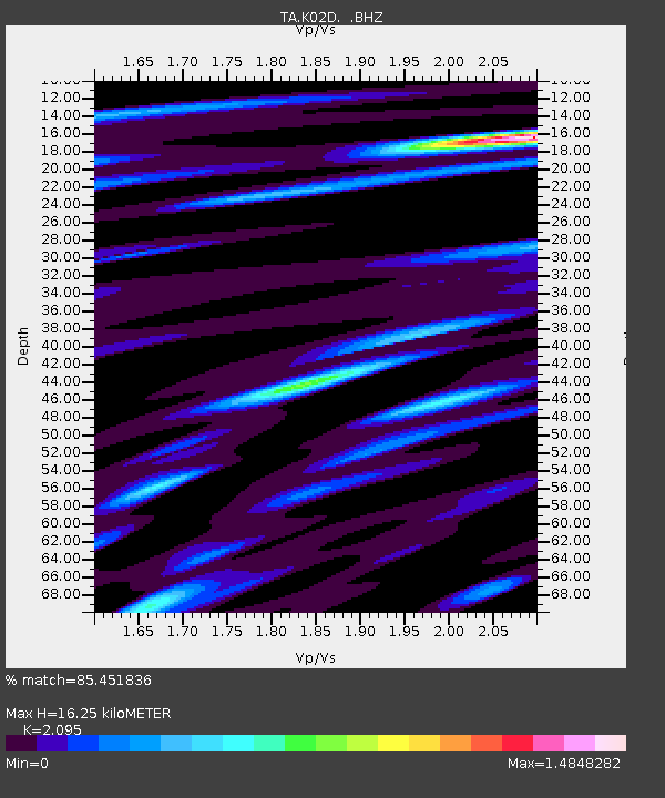
| Estimated Moho Depth: |
16.25 km |
| Estimated Crust Vp/Vs: |
2.10 |
| Assumed Crust Vp: |
6.522 km/s |
| Estimated Crust Vs: |
3.113 km/s |
| Estimated Crust Poisson's Ratio: |
0.35 |
|
| Radial Match: |
85.451836 % |
| Radial Bump: |
400 |
| Transverse Match: |
73.9626 % |
| Transverse Bump: |
400 |
| SOD ConfigId: |
751272 |
| Insert Time: |
2014-08-04 16:14:46.145 +0000 |
| GWidth: |
2.5 |
| Max Bumps: |
400 |
| Tol: |
0.001 |
|
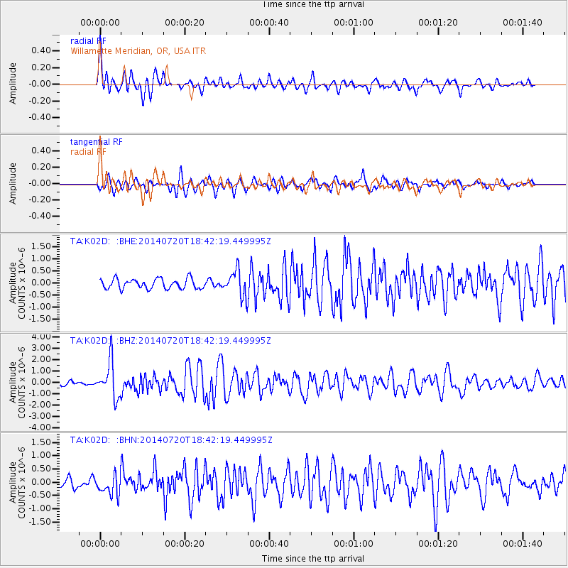
Signal To Noise
| Channel | StoN | STA | LTA |
| TA:K02D: :BHZ:20140720T18:42:19.449995Z | 10.909151 | 1.6553734E-6 | 1.5174172E-7 |
| TA:K02D: :BHN:20140720T18:42:19.449995Z | 2.1125245 | 3.8154562E-7 | 1.8061121E-7 |
| TA:K02D: :BHE:20140720T18:42:19.449995Z | 2.704746 | 5.503362E-7 | 2.0347058E-7 |
| Arrivals |
| Ps | 2.8 SECOND |
| PpPs | 7.4 SECOND |
| PsPs/PpSs | 10 SECOND |


