You are here: Home > Network List > TA - USArray Transportable Network (new EarthScope stations) Stations List
> Station K50A Casco, MI, USA > Earthquake Result Viewer
K50A Casco, MI, USA - Earthquake Result Viewer
| Earthquake location: |
Kuril Islands |
| Earthquake latitude/longitude: |
44.6/148.7 |
| Earthquake time(UTC): |
2014/07/20 (201) 18:32:47 GMT |
| Earthquake Depth: |
61 km |
| Earthquake Magnitude: |
6.6 MB |
| Earthquake Catalog/Contributor: |
NEIC PDE/NEIC COMCAT |
|
| Network: |
TA USArray Transportable Network (new EarthScope stations) |
| Station: |
K50A Casco, MI, USA |
| Lat/Lon: |
42.77 N/82.62 W |
| Elevation: |
191 m |
|
| Distance: |
81.6 deg |
| Az: |
35.536 deg |
| Baz: |
325.69 deg |
| Ray Param: |
0.047325622 |
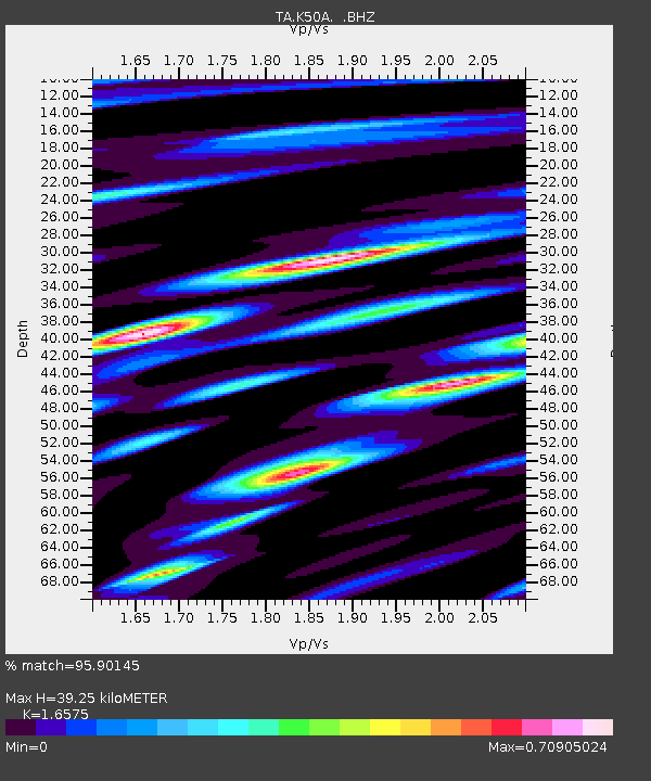
| Estimated Moho Depth: |
39.25 km |
| Estimated Crust Vp/Vs: |
1.66 |
| Assumed Crust Vp: |
6.483 km/s |
| Estimated Crust Vs: |
3.911 km/s |
| Estimated Crust Poisson's Ratio: |
0.21 |
|
| Radial Match: |
95.90145 % |
| Radial Bump: |
355 |
| Transverse Match: |
89.08911 % |
| Transverse Bump: |
400 |
| SOD ConfigId: |
751272 |
| Insert Time: |
2014-08-04 16:15:02.402 +0000 |
| GWidth: |
2.5 |
| Max Bumps: |
400 |
| Tol: |
0.001 |
|
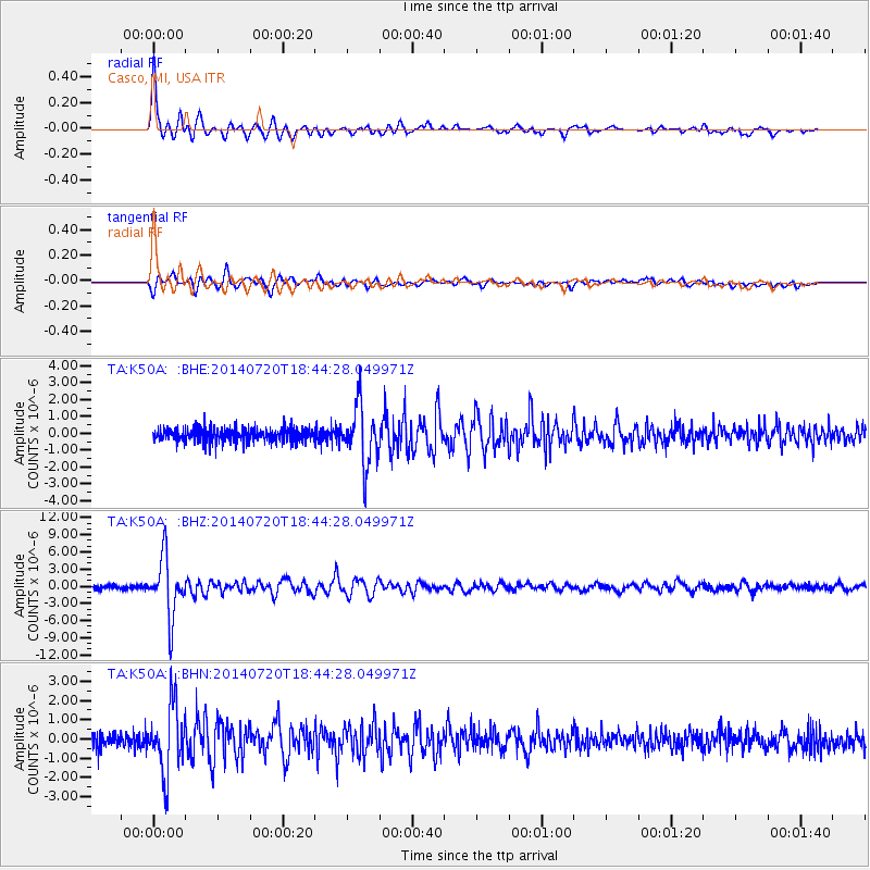
Signal To Noise
| Channel | StoN | STA | LTA |
| TA:K50A: :BHZ:20140720T18:44:28.049971Z | 18.45658 | 5.143566E-6 | 2.786847E-7 |
| TA:K50A: :BHN:20140720T18:44:28.049971Z | 5.2860594 | 1.7223589E-6 | 3.258304E-7 |
| TA:K50A: :BHE:20140720T18:44:28.049971Z | 4.368926 | 1.7643855E-6 | 4.038488E-7 |
| Arrivals |
| Ps | 4.1 SECOND |
| PpPs | 16 SECOND |
| PsPs/PpSs | 20 SECOND |


