You are here: Home > Network List > TA - USArray Transportable Network (new EarthScope stations) Stations List
> Station K51A Iona Station, ON, CAN > Earthquake Result Viewer
K51A Iona Station, ON, CAN - Earthquake Result Viewer
| Earthquake location: |
Kuril Islands |
| Earthquake latitude/longitude: |
44.6/148.7 |
| Earthquake time(UTC): |
2014/07/20 (201) 18:32:47 GMT |
| Earthquake Depth: |
61 km |
| Earthquake Magnitude: |
6.6 MB |
| Earthquake Catalog/Contributor: |
NEIC PDE/NEIC COMCAT |
|
| Network: |
TA USArray Transportable Network (new EarthScope stations) |
| Station: |
K51A Iona Station, ON, CAN |
| Lat/Lon: |
42.72 N/81.51 W |
| Elevation: |
217 m |
|
| Distance: |
82.1 deg |
| Az: |
34.878 deg |
| Baz: |
326.352 deg |
| Ray Param: |
0.046975594 |
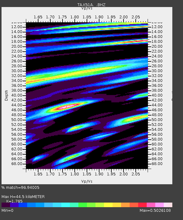
| Estimated Moho Depth: |
44.5 km |
| Estimated Crust Vp/Vs: |
1.76 |
| Assumed Crust Vp: |
6.53 km/s |
| Estimated Crust Vs: |
3.7 km/s |
| Estimated Crust Poisson's Ratio: |
0.26 |
|
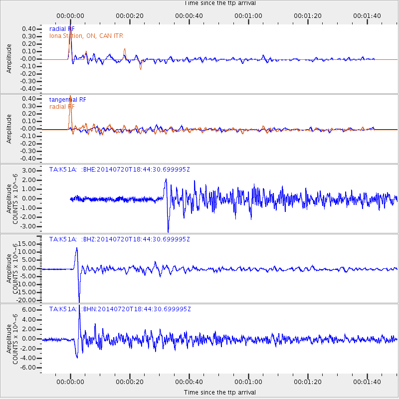
| Radial Match: |
96.94005 % |
| Radial Bump: |
349 |
| Transverse Match: |
86.485504 % |
| Transverse Bump: |
400 |
| SOD ConfigId: |
751272 |
| Insert Time: |
2014-08-04 16:15:03.139 +0000 |
| GWidth: |
2.5 |
| Max Bumps: |
400 |
| Tol: |
0.001 |
|
Signal To Noise
| Channel | StoN | STA | LTA |
| TA:K51A: :BHZ:20140720T18:44:30.699995Z | 66.76047 | 7.108704E-6 | 1.0648073E-7 |
| TA:K51A: :BHN:20140720T18:44:30.699995Z | 16.689665 | 2.2460563E-6 | 1.3457768E-7 |
| TA:K51A: :BHE:20140720T18:44:30.699995Z | 9.365541 | 1.26674E-6 | 1.3525539E-7 |
| Arrivals |
| Ps | 5.4 SECOND |
| PpPs | 18 SECOND |
| PsPs/PpSs | 24 SECOND |


