You are here: Home > Network List > TA - USArray Transportable Network (new EarthScope stations) Stations List
> Station K52A Tillsonburg, ON, CAN > Earthquake Result Viewer
K52A Tillsonburg, ON, CAN - Earthquake Result Viewer
| Earthquake location: |
Kuril Islands |
| Earthquake latitude/longitude: |
44.6/148.7 |
| Earthquake time(UTC): |
2014/07/20 (201) 18:32:47 GMT |
| Earthquake Depth: |
61 km |
| Earthquake Magnitude: |
6.6 MB |
| Earthquake Catalog/Contributor: |
NEIC PDE/NEIC COMCAT |
|
| Network: |
TA USArray Transportable Network (new EarthScope stations) |
| Station: |
K52A Tillsonburg, ON, CAN |
| Lat/Lon: |
42.78 N/80.71 W |
| Elevation: |
232 m |
|
| Distance: |
82.4 deg |
| Az: |
34.352 deg |
| Baz: |
326.818 deg |
| Ray Param: |
0.04678635 |
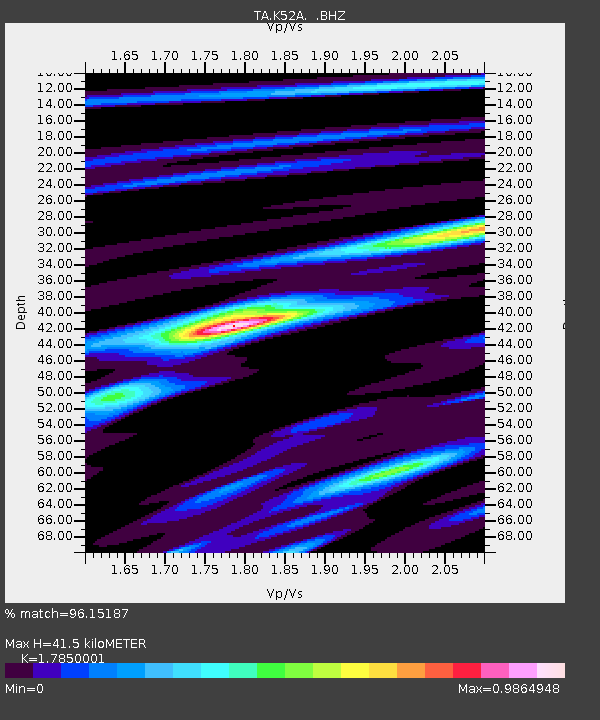
| Estimated Moho Depth: |
41.5 km |
| Estimated Crust Vp/Vs: |
1.79 |
| Assumed Crust Vp: |
6.53 km/s |
| Estimated Crust Vs: |
3.659 km/s |
| Estimated Crust Poisson's Ratio: |
0.27 |
|
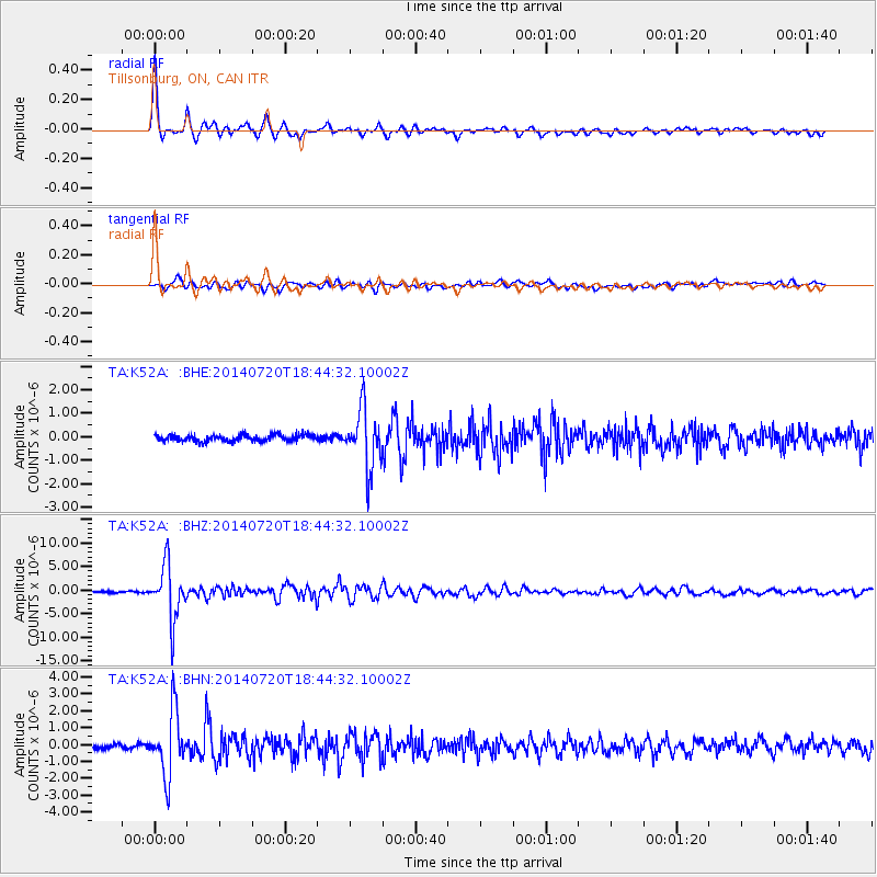
| Radial Match: |
96.15187 % |
| Radial Bump: |
348 |
| Transverse Match: |
83.48681 % |
| Transverse Bump: |
400 |
| SOD ConfigId: |
751272 |
| Insert Time: |
2014-08-04 16:15:10.298 +0000 |
| GWidth: |
2.5 |
| Max Bumps: |
400 |
| Tol: |
0.001 |
|
Signal To Noise
| Channel | StoN | STA | LTA |
| TA:K52A: :BHZ:20140720T18:44:32.10002Z | 43.03224 | 5.690412E-6 | 1.32236E-7 |
| TA:K52A: :BHN:20140720T18:44:32.10002Z | 14.235437 | 1.8611198E-6 | 1.3073851E-7 |
| TA:K52A: :BHE:20140720T18:44:32.10002Z | 9.023616 | 1.247309E-6 | 1.3822718E-7 |
| Arrivals |
| Ps | 5.1 SECOND |
| PpPs | 17 SECOND |
| PsPs/PpSs | 22 SECOND |


