You are here: Home > Network List > II - Global Seismograph Network (GSN - IRIS/IDA) Stations List
> Station NIL Nilore, Pakistan > Earthquake Result Viewer
NIL Nilore, Pakistan - Earthquake Result Viewer

| Earthquake location: |
Mid-Indian Ridge |
| Earthquake latitude/longitude: |
-11.4/66.2 |
| Earthquake time(UTC): |
1998/03/22 (081) 01:08:57 GMT |
| Earthquake Depth: |
10 km |
| Earthquake Magnitude: |
5.4 MB, 6.1 MS, 6.1 UNKNOWN, 6.1 MW |
| Earthquake Catalog/Contributor: |
WHDF/NEIC |
|
| Network: |
II Global Seismograph Network (GSN - IRIS/IDA) |
| Station: |
NIL Nilore, Pakistan |
| Lat/Lon: |
33.65 N/73.27 E |
| Elevation: |
629 m |
|
| Distance: |
45.3 deg |
| Az: |
8.247 deg |
| Baz: |
189.706 deg |
| Ray Param: |
0.07135246 |
| Estimated Moho Depth: |
16.25 km |
| Estimated Crust Vp/Vs: |
1.60 |
| Assumed Crust Vp: |
6.242 km/s |
| Estimated Crust Vs: |
3.901 km/s |
| Estimated Crust Poisson's Ratio: |
0.18 |
|
| Radial Match: |
88.93202 % |
| Radial Bump: |
400 |
| Transverse Match: |
76.87695 % |
| Transverse Bump: |
400 |
| SOD ConfigId: |
4480 |
| Insert Time: |
2010-03-02 00:22:50.707 +0000 |
| GWidth: |
2.5 |
| Max Bumps: |
400 |
| Tol: |
0.001 |
|
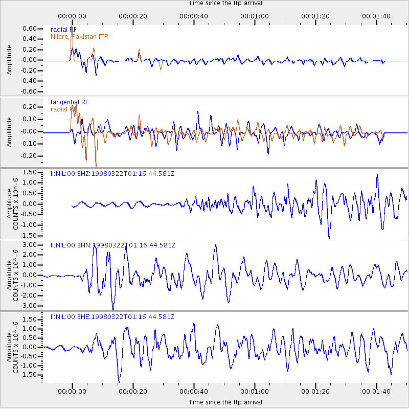
Signal To Noise
| Channel | StoN | STA | LTA |
| II:NIL:00:BHN:19980322T01:16:44.581Z | 3.4166343 | 2.2149646E-7 | 6.4828846E-8 |
| II:NIL:00:BHE:19980322T01:16:44.581Z | 1.9788204 | 9.459216E-8 | 4.7802295E-8 |
| II:NIL:00:BHZ:19980322T01:16:44.581Z | 0.38190532 | 3.3774626E-8 | 8.8437176E-8 |
| Arrivals |
| Ps | 1.7 SECOND |
| PpPs | 6.3 SECOND |
| PsPs/PpSs | 8.0 SECOND |


