You are here: Home > Network List > TA - USArray Transportable Network (new EarthScope stations) Stations List
> Station K57A Scipio Center, NY, USA > Earthquake Result Viewer
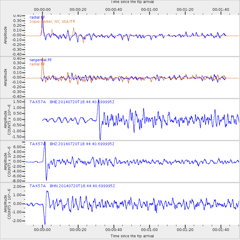
K57A Scipio Center, NY, USA - Earthquake Result Viewer
| Earthquake location: |
Kuril Islands |
| Earthquake latitude/longitude: |
44.6/148.7 |
| Earthquake time(UTC): |
2014/07/20 (201) 18:32:47 GMT |
| Earthquake Depth: |
61 km |
| Earthquake Magnitude: |
6.6 MB |
| Earthquake Catalog/Contributor: |
NEIC PDE/NEIC COMCAT |
|
| Network: |
TA USArray Transportable Network (new EarthScope stations) |
| Station: |
K57A Scipio Center, NY, USA |
| Lat/Lon: |
42.73 N/76.52 W |
| Elevation: |
408 m |
|
| Distance: |
84.1 deg |
| Az: |
31.736 deg |
| Baz: |
329.351 deg |
| Ray Param: |
0.045612846 |
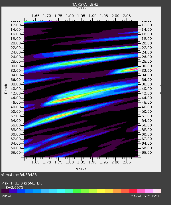
| Estimated Moho Depth: |
31.0 km |
| Estimated Crust Vp/Vs: |
2.10 |
| Assumed Crust Vp: |
6.476 km/s |
| Estimated Crust Vs: |
3.087 km/s |
| Estimated Crust Poisson's Ratio: |
0.35 |
|
| Radial Match: |
86.68435 % |
| Radial Bump: |
280 |
| Transverse Match: |
75.275696 % |
| Transverse Bump: |
400 |
| SOD ConfigId: |
751272 |
| Insert Time: |
2014-08-04 16:15:29.412 +0000 |
| GWidth: |
2.5 |
| Max Bumps: |
400 |
| Tol: |
0.001 |
|
Signal To Noise
| Channel | StoN | STA | LTA |
| TA:K57A: :BHZ:20140720T18:44:40.699995Z | 36.3634 | 3.7864284E-6 | 1.0412745E-7 |
| TA:K57A: :BHN:20140720T18:44:40.699995Z | 11.996616 | 1.0843692E-6 | 9.0389584E-8 |
| TA:K57A: :BHE:20140720T18:44:40.699995Z | 5.930033 | 8.443376E-7 | 1.4238329E-7 |
| Arrivals |
| Ps | 5.4 SECOND |
| PpPs | 15 SECOND |
| PsPs/PpSs | 20 SECOND |


