You are here: Home > Network List > TA - USArray Transportable Network (new EarthScope stations) Stations List
> Station K59A Cooperstown, NY, USA > Earthquake Result Viewer
K59A Cooperstown, NY, USA - Earthquake Result Viewer
| Earthquake location: |
Kuril Islands |
| Earthquake latitude/longitude: |
44.6/148.7 |
| Earthquake time(UTC): |
2014/07/20 (201) 18:32:47 GMT |
| Earthquake Depth: |
61 km |
| Earthquake Magnitude: |
6.6 MB |
| Earthquake Catalog/Contributor: |
NEIC PDE/NEIC COMCAT |
|
| Network: |
TA USArray Transportable Network (new EarthScope stations) |
| Station: |
K59A Cooperstown, NY, USA |
| Lat/Lon: |
42.78 N/74.85 W |
| Elevation: |
570 m |
|
| Distance: |
84.7 deg |
| Az: |
30.649 deg |
| Baz: |
330.37 deg |
| Ray Param: |
0.045200642 |
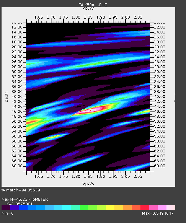
| Estimated Moho Depth: |
45.25 km |
| Estimated Crust Vp/Vs: |
1.86 |
| Assumed Crust Vp: |
6.419 km/s |
| Estimated Crust Vs: |
3.456 km/s |
| Estimated Crust Poisson's Ratio: |
0.30 |
|
| Radial Match: |
94.35539 % |
| Radial Bump: |
369 |
| Transverse Match: |
90.433655 % |
| Transverse Bump: |
400 |
| SOD ConfigId: |
751272 |
| Insert Time: |
2014-08-04 16:15:37.196 +0000 |
| GWidth: |
2.5 |
| Max Bumps: |
400 |
| Tol: |
0.001 |
|

Signal To Noise
| Channel | StoN | STA | LTA |
| TA:K59A: :BHZ:20140720T18:44:43.60002Z | 66.77655 | 5.7348475E-6 | 8.5881155E-8 |
| TA:K59A: :BHN:20140720T18:44:43.60002Z | 13.1889105 | 1.7461537E-6 | 1.323956E-7 |
| TA:K59A: :BHE:20140720T18:44:43.60002Z | 15.824301 | 1.2895282E-6 | 8.149037E-8 |
| Arrivals |
| Ps | 6.2 SECOND |
| PpPs | 20 SECOND |
| PsPs/PpSs | 26 SECOND |


