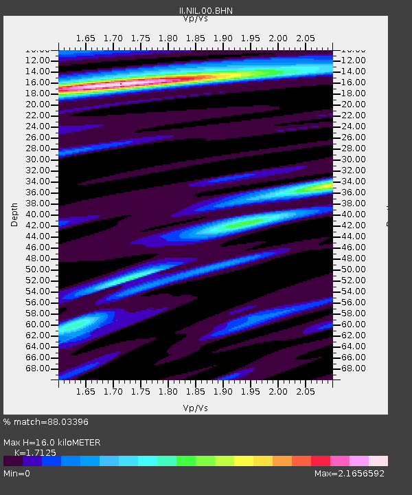
NIL Nilore, Pakistan - Earthquake Result Viewer

Earthquake location: Southern Sumatra, Indonesia
Earthquake latitude/longitude: -0.5/99.3
Earthquake time(UTC): 1998/04/01 (091) 17:56:23 GMT
Earthquake Depth: 56 km
Earthquake Magnitude: 6.2 MB, 6.9 MS, 7.0 UNKNOWN, 6.6 ME
Earthquake Catalog/Contributor: WHDF/NEIC
Network: II Global Seismograph Network (GSN - IRIS/IDA)
Station: NIL Nilore, Pakistan
Lat/Lon: 33.65 N/73.27 E
Elevation: 629 m
Distance: 41.9 deg
Az: 326.798 deg
Baz: 138.971 deg
Ray Param: 0.07334739
Estimated Moho Depth: 16.0 km
Estimated Crust Vp/Vs: 1.71
Assumed Crust Vp: 6.242 km/s
Estimated Crust Vs: 3.645 km/s
Estimated Crust Poisson's Ratio: 0.24
Radial Match: 88.03396 %
Radial Bump: 400
Transverse Match: 71.58116 %
Transverse Bump: 400
SOD ConfigId: 4480
Insert Time: 2010-03-02 00:22:54.557 +0000
GWidth: 2.5
Max Bumps: 400
Tol: 0.001

Signal To Noise

ChannelStoNSTALTA
II:NIL:00:BHN:19980401T18:03:37.638013Z45.2823758.07866E-61.7840628E-7
II:NIL:00:BHE:19980401T18:03:37.638013Z24.1353682.5282222E-61.0475176E-7
II:NIL:00:BHZ:19980401T18:03:37.638013Z27.6855092.3120945E-68.35128E-8
Arrivals
Ps2.0 SECOND
PpPs6.5 SECOND
PsPs/PpSs8.5 SECOND