You are here: Home > Network List > TA - USArray Transportable Network (new EarthScope stations) Stations List
> Station L60A Shokan, NY, USA > Earthquake Result Viewer
L60A Shokan, NY, USA - Earthquake Result Viewer
| Earthquake location: |
Kuril Islands |
| Earthquake latitude/longitude: |
44.6/148.7 |
| Earthquake time(UTC): |
2014/07/20 (201) 18:32:47 GMT |
| Earthquake Depth: |
61 km |
| Earthquake Magnitude: |
6.6 MB |
| Earthquake Catalog/Contributor: |
NEIC PDE/NEIC COMCAT |
|
| Network: |
TA USArray Transportable Network (new EarthScope stations) |
| Station: |
L60A Shokan, NY, USA |
| Lat/Lon: |
41.99 N/74.22 W |
| Elevation: |
388 m |
|
| Distance: |
85.6 deg |
| Az: |
30.629 deg |
| Baz: |
330.791 deg |
| Ray Param: |
0.044546433 |
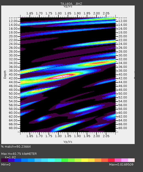
| Estimated Moho Depth: |
40.75 km |
| Estimated Crust Vp/Vs: |
1.82 |
| Assumed Crust Vp: |
6.283 km/s |
| Estimated Crust Vs: |
3.452 km/s |
| Estimated Crust Poisson's Ratio: |
0.28 |
|
| Radial Match: |
90.23664 % |
| Radial Bump: |
400 |
| Transverse Match: |
89.41356 % |
| Transverse Bump: |
400 |
| SOD ConfigId: |
751272 |
| Insert Time: |
2014-08-04 16:16:45.998 +0000 |
| GWidth: |
2.5 |
| Max Bumps: |
400 |
| Tol: |
0.001 |
|

Signal To Noise
| Channel | StoN | STA | LTA |
| TA:L60A: :BHZ:20140720T18:44:48.150007Z | 24.915558 | 4.9676014E-6 | 1.993775E-7 |
| TA:L60A: :BHN:20140720T18:44:48.150007Z | 13.800888 | 1.5451129E-6 | 1.119575E-7 |
| TA:L60A: :BHE:20140720T18:44:48.150007Z | 9.169686 | 9.747326E-7 | 1.0629945E-7 |
| Arrivals |
| Ps | 5.4 SECOND |
| PpPs | 18 SECOND |
| PsPs/PpSs | 23 SECOND |


