You are here: Home > Network List > TA - USArray Transportable Network (new EarthScope stations) Stations List
> Station M63A Gales Ferry, CT, USA > Earthquake Result Viewer
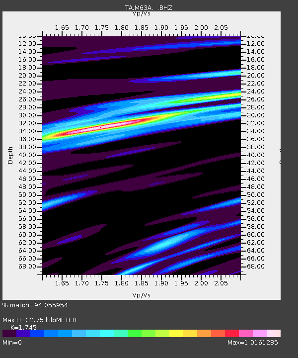
M63A Gales Ferry, CT, USA - Earthquake Result Viewer
| Earthquake location: |
Kuril Islands |
| Earthquake latitude/longitude: |
44.6/148.7 |
| Earthquake time(UTC): |
2014/07/20 (201) 18:32:47 GMT |
| Earthquake Depth: |
61 km |
| Earthquake Magnitude: |
6.6 MB |
| Earthquake Catalog/Contributor: |
NEIC PDE/NEIC COMCAT |
|
| Network: |
TA USArray Transportable Network (new EarthScope stations) |
| Station: |
M63A Gales Ferry, CT, USA |
| Lat/Lon: |
41.40 N/72.05 W |
| Elevation: |
44 m |
|
| Distance: |
86.9 deg |
| Az: |
29.474 deg |
| Baz: |
332.158 deg |
| Ray Param: |
0.043619156 |
| Estimated Moho Depth: |
32.75 km |
| Estimated Crust Vp/Vs: |
1.75 |
| Assumed Crust Vp: |
6.472 km/s |
| Estimated Crust Vs: |
3.709 km/s |
| Estimated Crust Poisson's Ratio: |
0.26 |
|
| Radial Match: |
94.055954 % |
| Radial Bump: |
323 |
| Transverse Match: |
83.54402 % |
| Transverse Bump: |
358 |
| SOD ConfigId: |
751272 |
| Insert Time: |
2014-08-04 16:18:09.039 +0000 |
| GWidth: |
2.5 |
| Max Bumps: |
400 |
| Tol: |
0.001 |
|

Signal To Noise
| Channel | StoN | STA | LTA |
| TA:M63A: :BHZ:20140720T18:44:54.47502Z | 31.093012 | 4.13858E-6 | 1.3310323E-7 |
| TA:M63A: :BHN:20140720T18:44:54.47502Z | 10.076703 | 1.2910439E-6 | 1.2812166E-7 |
| TA:M63A: :BHE:20140720T18:44:54.47502Z | 9.686244 | 1.1314014E-6 | 1.1680497E-7 |
| Arrivals |
| Ps | 3.9 SECOND |
| PpPs | 14 SECOND |
| PsPs/PpSs | 17 SECOND |


