You are here: Home > Network List > TA - USArray Transportable Network (new EarthScope stations) Stations List
> Station N57A Milroy, PA, USA > Earthquake Result Viewer
N57A Milroy, PA, USA - Earthquake Result Viewer
| Earthquake location: |
Kuril Islands |
| Earthquake latitude/longitude: |
44.6/148.7 |
| Earthquake time(UTC): |
2014/07/20 (201) 18:32:47 GMT |
| Earthquake Depth: |
61 km |
| Earthquake Magnitude: |
6.6 MB |
| Earthquake Catalog/Contributor: |
NEIC PDE/NEIC COMCAT |
|
| Network: |
TA USArray Transportable Network (new EarthScope stations) |
| Station: |
N57A Milroy, PA, USA |
| Lat/Lon: |
40.76 N/77.55 W |
| Elevation: |
306 m |
|
| Distance: |
85.4 deg |
| Az: |
33.422 deg |
| Baz: |
328.819 deg |
| Ray Param: |
0.0446859 |
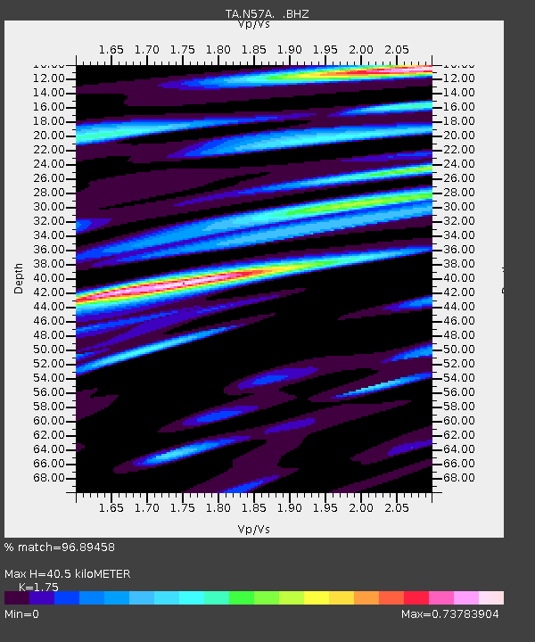
| Estimated Moho Depth: |
40.5 km |
| Estimated Crust Vp/Vs: |
1.75 |
| Assumed Crust Vp: |
6.121 km/s |
| Estimated Crust Vs: |
3.497 km/s |
| Estimated Crust Poisson's Ratio: |
0.26 |
|
| Radial Match: |
96.89458 % |
| Radial Bump: |
400 |
| Transverse Match: |
90.88626 % |
| Transverse Bump: |
400 |
| SOD ConfigId: |
751272 |
| Insert Time: |
2014-08-04 16:19:07.240 +0000 |
| GWidth: |
2.5 |
| Max Bumps: |
400 |
| Tol: |
0.001 |
|
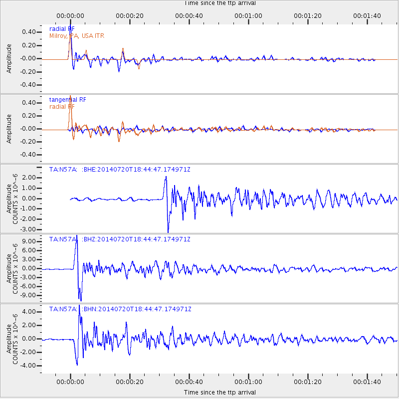
Signal To Noise
| Channel | StoN | STA | LTA |
| TA:N57A: :BHZ:20140720T18:44:47.174971Z | 63.706394 | 5.5195246E-6 | 8.664004E-8 |
| TA:N57A: :BHN:20140720T18:44:47.174971Z | 26.61528 | 2.1356086E-6 | 8.0239936E-8 |
| TA:N57A: :BHE:20140720T18:44:47.174971Z | 15.101623 | 1.2704692E-6 | 8.412799E-8 |
| Arrivals |
| Ps | 5.1 SECOND |
| PpPs | 18 SECOND |
| PsPs/PpSs | 23 SECOND |


