You are here: Home > Network List > II - Global Seismograph Network (GSN - IRIS/IDA) Stations List
> Station NIL Nilore, Pakistan > Earthquake Result Viewer
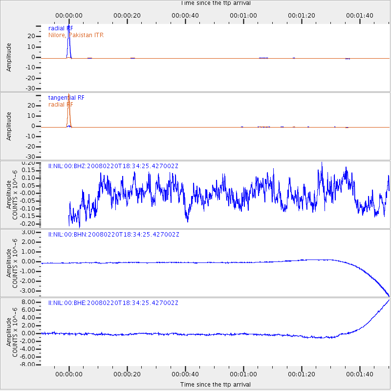
NIL Nilore, Pakistan - Earthquake Result Viewer

| Earthquake location: |
Southern Greece |
| Earthquake latitude/longitude: |
36.3/21.8 |
| Earthquake time(UTC): |
2008/02/20 (051) 18:27:06 GMT |
| Earthquake Depth: |
9.9 km |
| Earthquake Magnitude: |
5.7 MB, 6.1 MS, 6.1 MW, 6.1 MW |
| Earthquake Catalog/Contributor: |
WHDF/NEIC |
|
| Network: |
II Global Seismograph Network (GSN - IRIS/IDA) |
| Station: |
NIL Nilore, Pakistan |
| Lat/Lon: |
33.65 N/73.27 E |
| Elevation: |
629 m |
|
| Distance: |
41.9 deg |
| Az: |
77.929 deg |
| Baz: |
288.707 deg |
| Ray Param: |
0.07351472 |
| Estimated Moho Depth: |
10.0 km |
| Estimated Crust Vp/Vs: |
1.60 |
| Assumed Crust Vp: |
6.242 km/s |
| Estimated Crust Vs: |
3.901 km/s |
| Estimated Crust Poisson's Ratio: |
0.18 |
|
| Radial Match: |
99.75209 % |
| Radial Bump: |
23 |
| Transverse Match: |
99.554245 % |
| Transverse Bump: |
39 |
| SOD ConfigId: |
2564 |
| Insert Time: |
2010-03-02 00:23:03.663 +0000 |
| GWidth: |
2.5 |
| Max Bumps: |
400 |
| Tol: |
0.001 |
|
Signal To Noise
| Channel | StoN | STA | LTA |
| II:NIL:00:BHN:20080220T18:34:25.427002Z | 0.88703704 | 2.3873284E-7 | 2.691351E-7 |
| II:NIL:00:BHE:20080220T18:34:25.427002Z | 0.8318456 | 6.25552E-7 | 7.52005E-7 |
| II:NIL:00:BHZ:20080220T18:34:25.427002Z | 0.9095338 | 7.4868744E-8 | 8.231551E-8 |
| Arrivals |
| Ps | 1.0 SECOND |
| PpPs | 3.9 SECOND |
| PsPs/PpSs | 4.9 SECOND |


