You are here: Home > Network List > TA - USArray Transportable Network (new EarthScope stations) Stations List
> Station O52A Adamsville, OH, USA > Earthquake Result Viewer
O52A Adamsville, OH, USA - Earthquake Result Viewer
| Earthquake location: |
Kuril Islands |
| Earthquake latitude/longitude: |
44.6/148.7 |
| Earthquake time(UTC): |
2014/07/20 (201) 18:32:47 GMT |
| Earthquake Depth: |
61 km |
| Earthquake Magnitude: |
6.6 MB |
| Earthquake Catalog/Contributor: |
NEIC PDE/NEIC COMCAT |
|
| Network: |
TA USArray Transportable Network (new EarthScope stations) |
| Station: |
O52A Adamsville, OH, USA |
| Lat/Lon: |
40.12 N/81.84 W |
| Elevation: |
331 m |
|
| Distance: |
84.2 deg |
| Az: |
36.538 deg |
| Baz: |
326.333 deg |
| Ray Param: |
0.04555647 |
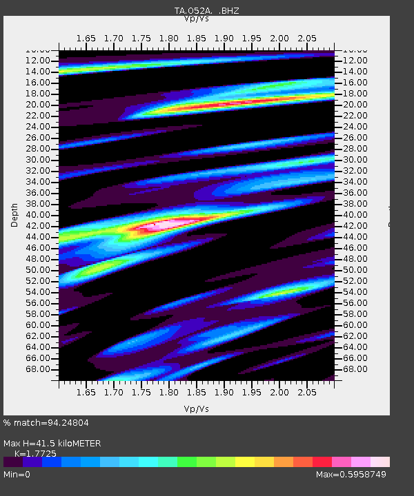
| Estimated Moho Depth: |
41.5 km |
| Estimated Crust Vp/Vs: |
1.77 |
| Assumed Crust Vp: |
6.483 km/s |
| Estimated Crust Vs: |
3.657 km/s |
| Estimated Crust Poisson's Ratio: |
0.27 |
|
| Radial Match: |
94.24804 % |
| Radial Bump: |
400 |
| Transverse Match: |
90.93951 % |
| Transverse Bump: |
400 |
| SOD ConfigId: |
751272 |
| Insert Time: |
2014-08-04 16:19:46.684 +0000 |
| GWidth: |
2.5 |
| Max Bumps: |
400 |
| Tol: |
0.001 |
|

Signal To Noise
| Channel | StoN | STA | LTA |
| TA:O52A: :BHZ:20140720T18:44:41.10002Z | 56.18467 | 5.1547263E-6 | 9.174614E-8 |
| TA:O52A: :BHN:20140720T18:44:41.10002Z | 10.496316 | 1.6964316E-6 | 1.6162163E-7 |
| TA:O52A: :BHE:20140720T18:44:41.10002Z | 14.084783 | 1.4147854E-6 | 1.004478E-7 |
| Arrivals |
| Ps | 5.1 SECOND |
| PpPs | 17 SECOND |
| PsPs/PpSs | 22 SECOND |


