You are here: Home > Network List > TA - USArray Transportable Network (new EarthScope stations) Stations List
> Station P54A Burton, WV, USA > Earthquake Result Viewer
P54A Burton, WV, USA - Earthquake Result Viewer
| Earthquake location: |
Kuril Islands |
| Earthquake latitude/longitude: |
44.6/148.7 |
| Earthquake time(UTC): |
2014/07/20 (201) 18:32:47 GMT |
| Earthquake Depth: |
61 km |
| Earthquake Magnitude: |
6.6 MB |
| Earthquake Catalog/Contributor: |
NEIC PDE/NEIC COMCAT |
|
| Network: |
TA USArray Transportable Network (new EarthScope stations) |
| Station: |
P54A Burton, WV, USA |
| Lat/Lon: |
39.61 N/80.48 W |
| Elevation: |
473 m |
|
| Distance: |
85.2 deg |
| Az: |
35.94 deg |
| Baz: |
327.144 deg |
| Ray Param: |
0.04484261 |
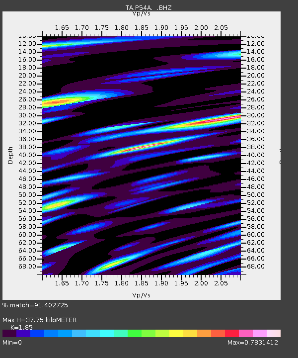
| Estimated Moho Depth: |
37.75 km |
| Estimated Crust Vp/Vs: |
1.85 |
| Assumed Crust Vp: |
6.207 km/s |
| Estimated Crust Vs: |
3.355 km/s |
| Estimated Crust Poisson's Ratio: |
0.29 |
|
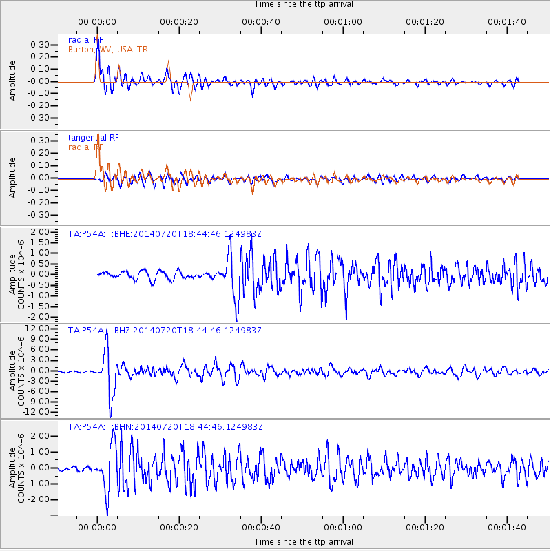
| Radial Match: |
91.402725 % |
| Radial Bump: |
400 |
| Transverse Match: |
83.775185 % |
| Transverse Bump: |
400 |
| SOD ConfigId: |
751272 |
| Insert Time: |
2014-08-04 16:21:10.408 +0000 |
| GWidth: |
2.5 |
| Max Bumps: |
400 |
| Tol: |
0.001 |
|
Signal To Noise
| Channel | StoN | STA | LTA |
| TA:P54A: :BHZ:20140720T18:44:46.124983Z | 36.99405 | 6.2980544E-6 | 1.7024507E-7 |
| TA:P54A: :BHN:20140720T18:44:46.124983Z | 12.675657 | 1.4068185E-6 | 1.1098584E-7 |
| TA:P54A: :BHE:20140720T18:44:46.124983Z | 5.882783 | 1.0459873E-6 | 1.7780485E-7 |
| Arrivals |
| Ps | 5.3 SECOND |
| PpPs | 17 SECOND |
| PsPs/PpSs | 22 SECOND |


