You are here: Home > Network List > TA - USArray Transportable Network (new EarthScope stations) Stations List
> Station P57A Homestead Farm, Martinsburg, WV, USA > Earthquake Result Viewer
P57A Homestead Farm, Martinsburg, WV, USA - Earthquake Result Viewer
| Earthquake location: |
Kuril Islands |
| Earthquake latitude/longitude: |
44.6/148.7 |
| Earthquake time(UTC): |
2014/07/20 (201) 18:32:47 GMT |
| Earthquake Depth: |
61 km |
| Earthquake Magnitude: |
6.6 MB |
| Earthquake Catalog/Contributor: |
NEIC PDE/NEIC COMCAT |
|
| Network: |
TA USArray Transportable Network (new EarthScope stations) |
| Station: |
P57A Homestead Farm, Martinsburg, WV, USA |
| Lat/Lon: |
39.48 N/78.01 W |
| Elevation: |
191 m |
|
| Distance: |
86.3 deg |
| Az: |
34.387 deg |
| Baz: |
328.593 deg |
| Ray Param: |
0.044045873 |
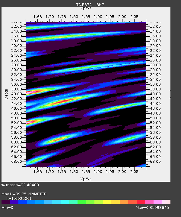
| Estimated Moho Depth: |
39.25 km |
| Estimated Crust Vp/Vs: |
1.60 |
| Assumed Crust Vp: |
6.159 km/s |
| Estimated Crust Vs: |
3.843 km/s |
| Estimated Crust Poisson's Ratio: |
0.18 |
|
| Radial Match: |
93.48483 % |
| Radial Bump: |
400 |
| Transverse Match: |
89.92089 % |
| Transverse Bump: |
400 |
| SOD ConfigId: |
751272 |
| Insert Time: |
2014-08-04 16:21:19.247 +0000 |
| GWidth: |
2.5 |
| Max Bumps: |
400 |
| Tol: |
0.001 |
|
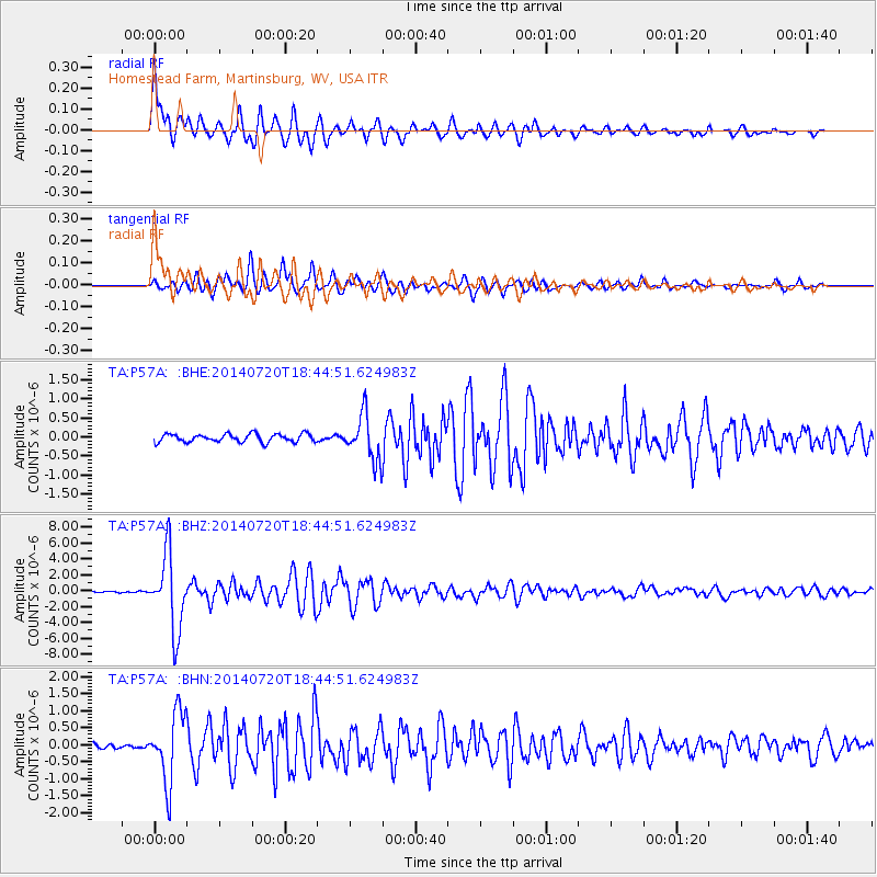
Signal To Noise
| Channel | StoN | STA | LTA |
| TA:P57A: :BHZ:20140720T18:44:51.624983Z | 32.822693 | 4.780405E-6 | 1.4564328E-7 |
| TA:P57A: :BHN:20140720T18:44:51.624983Z | 8.595954 | 1.0171183E-6 | 1.1832523E-7 |
| TA:P57A: :BHE:20140720T18:44:51.624983Z | 5.5495925 | 5.9318234E-7 | 1.0688755E-7 |
| Arrivals |
| Ps | 3.9 SECOND |
| PpPs | 16 SECOND |
| PsPs/PpSs | 20 SECOND |


