You are here: Home > Network List > TA - USArray Transportable Network (new EarthScope stations) Stations List
> Station P59A Jarrettsville, MD, USA > Earthquake Result Viewer
P59A Jarrettsville, MD, USA - Earthquake Result Viewer
| Earthquake location: |
Kuril Islands |
| Earthquake latitude/longitude: |
44.6/148.7 |
| Earthquake time(UTC): |
2014/07/20 (201) 18:32:47 GMT |
| Earthquake Depth: |
61 km |
| Earthquake Magnitude: |
6.6 MB |
| Earthquake Catalog/Contributor: |
NEIC PDE/NEIC COMCAT |
|
| Network: |
TA USArray Transportable Network (new EarthScope stations) |
| Station: |
P59A Jarrettsville, MD, USA |
| Lat/Lon: |
39.61 N/76.43 W |
| Elevation: |
157 m |
|
| Distance: |
86.8 deg |
| Az: |
33.272 deg |
| Baz: |
329.528 deg |
| Ray Param: |
0.043667063 |
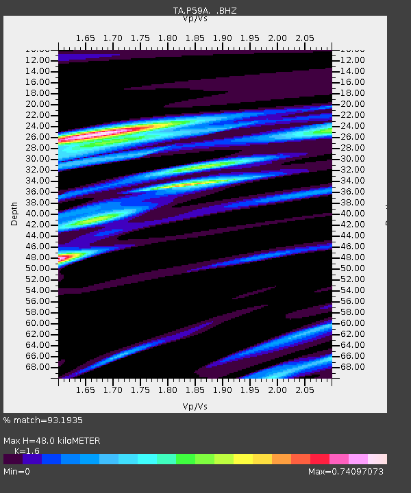
| Estimated Moho Depth: |
48.0 km |
| Estimated Crust Vp/Vs: |
1.60 |
| Assumed Crust Vp: |
6.419 km/s |
| Estimated Crust Vs: |
4.012 km/s |
| Estimated Crust Poisson's Ratio: |
0.18 |
|
| Radial Match: |
93.1935 % |
| Radial Bump: |
395 |
| Transverse Match: |
84.994934 % |
| Transverse Bump: |
400 |
| SOD ConfigId: |
751272 |
| Insert Time: |
2014-08-04 16:21:27.707 +0000 |
| GWidth: |
2.5 |
| Max Bumps: |
400 |
| Tol: |
0.001 |
|

Signal To Noise
| Channel | StoN | STA | LTA |
| TA:P59A: :BHZ:20140720T18:44:54.150007Z | 51.62109 | 5.7656557E-6 | 1.1169186E-7 |
| TA:P59A: :BHN:20140720T18:44:54.150007Z | 21.412876 | 2.2119443E-6 | 1.03299726E-7 |
| TA:P59A: :BHE:20140720T18:44:54.150007Z | 15.017826 | 1.3623923E-6 | 9.0718345E-8 |
| Arrivals |
| Ps | 4.6 SECOND |
| PpPs | 19 SECOND |
| PsPs/PpSs | 24 SECOND |


