You are here: Home > Network List > TA - USArray Transportable Network (new EarthScope stations) Stations List
> Station Q59A Harwood, MD, USA > Earthquake Result Viewer
Q59A Harwood, MD, USA - Earthquake Result Viewer
| Earthquake location: |
Kuril Islands |
| Earthquake latitude/longitude: |
44.6/148.7 |
| Earthquake time(UTC): |
2014/07/20 (201) 18:32:47 GMT |
| Earthquake Depth: |
61 km |
| Earthquake Magnitude: |
6.6 MB |
| Earthquake Catalog/Contributor: |
NEIC PDE/NEIC COMCAT |
|
| Network: |
TA USArray Transportable Network (new EarthScope stations) |
| Station: |
Q59A Harwood, MD, USA |
| Lat/Lon: |
38.86 N/76.65 W |
| Elevation: |
34 m |
|
| Distance: |
87.4 deg |
| Az: |
33.8 deg |
| Baz: |
329.415 deg |
| Ray Param: |
0.043270003 |
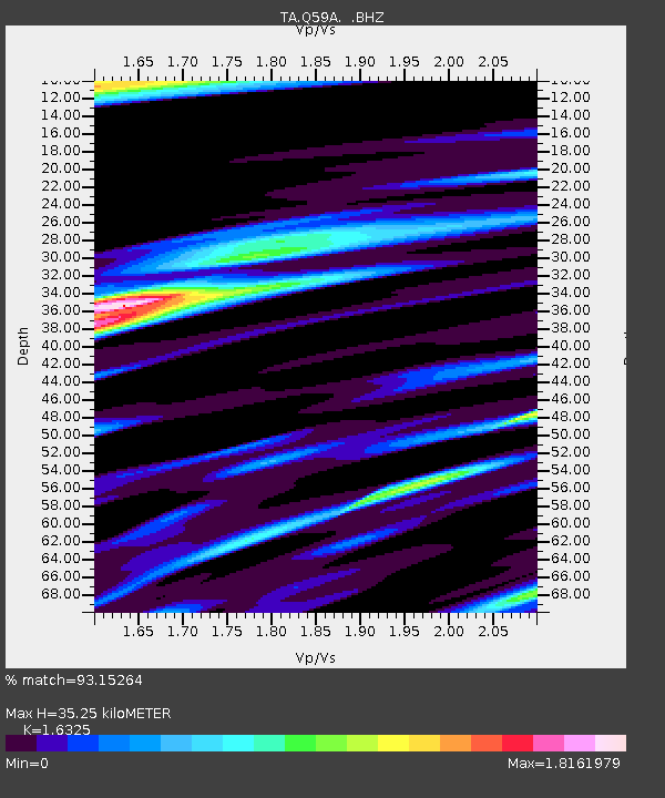
| Estimated Moho Depth: |
35.25 km |
| Estimated Crust Vp/Vs: |
1.63 |
| Assumed Crust Vp: |
6.419 km/s |
| Estimated Crust Vs: |
3.932 km/s |
| Estimated Crust Poisson's Ratio: |
0.20 |
|
| Radial Match: |
93.15264 % |
| Radial Bump: |
400 |
| Transverse Match: |
85.99688 % |
| Transverse Bump: |
400 |
| SOD ConfigId: |
751272 |
| Insert Time: |
2014-08-04 16:22:18.214 +0000 |
| GWidth: |
2.5 |
| Max Bumps: |
400 |
| Tol: |
0.001 |
|
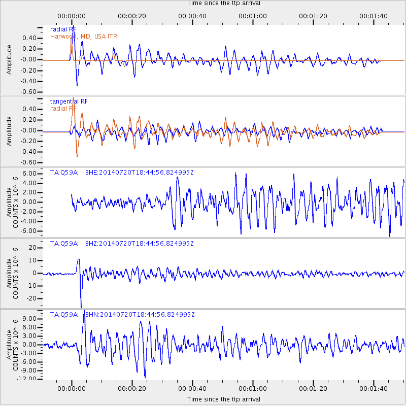
Signal To Noise
| Channel | StoN | STA | LTA |
| TA:Q59A: :BHZ:20140720T18:44:56.824995Z | 21.376888 | 8.342454E-6 | 3.9025574E-7 |
| TA:Q59A: :BHN:20140720T18:44:56.824995Z | 7.6717453 | 4.404603E-6 | 5.741331E-7 |
| TA:Q59A: :BHE:20140720T18:44:56.824995Z | 3.601562 | 2.4748367E-6 | 6.871565E-7 |
| Arrivals |
| Ps | 3.6 SECOND |
| PpPs | 14 SECOND |
| PsPs/PpSs | 18 SECOND |


