You are here: Home > Network List > TA - USArray Transportable Network (new EarthScope stations) Stations List
> Station Q60A Greensboro, MD, USA > Earthquake Result Viewer
Q60A Greensboro, MD, USA - Earthquake Result Viewer

| Earthquake location: |
Kuril Islands |
| Earthquake latitude/longitude: |
44.6/148.7 |
| Earthquake time(UTC): |
2014/07/20 (201) 18:32:47 GMT |
| Earthquake Depth: |
61 km |
| Earthquake Magnitude: |
6.6 MB |
| Earthquake Catalog/Contributor: |
NEIC PDE/NEIC COMCAT |
|
| Network: |
TA USArray Transportable Network (new EarthScope stations) |
| Station: |
Q60A Greensboro, MD, USA |
| Lat/Lon: |
39.00 N/75.84 W |
| Elevation: |
14 m |
|
| Distance: |
87.6 deg |
| Az: |
33.183 deg |
| Baz: |
329.896 deg |
| Ray Param: |
0.043121647 |
| Estimated Moho Depth: |
43.5 km |
| Estimated Crust Vp/Vs: |
2.10 |
| Assumed Crust Vp: |
6.287 km/s |
| Estimated Crust Vs: |
2.998 km/s |
| Estimated Crust Poisson's Ratio: |
0.35 |
|
| Radial Match: |
85.394485 % |
| Radial Bump: |
400 |
| Transverse Match: |
76.673935 % |
| Transverse Bump: |
400 |
| SOD ConfigId: |
751272 |
| Insert Time: |
2014-08-04 16:22:24.823 +0000 |
| GWidth: |
2.5 |
| Max Bumps: |
400 |
| Tol: |
0.001 |
|
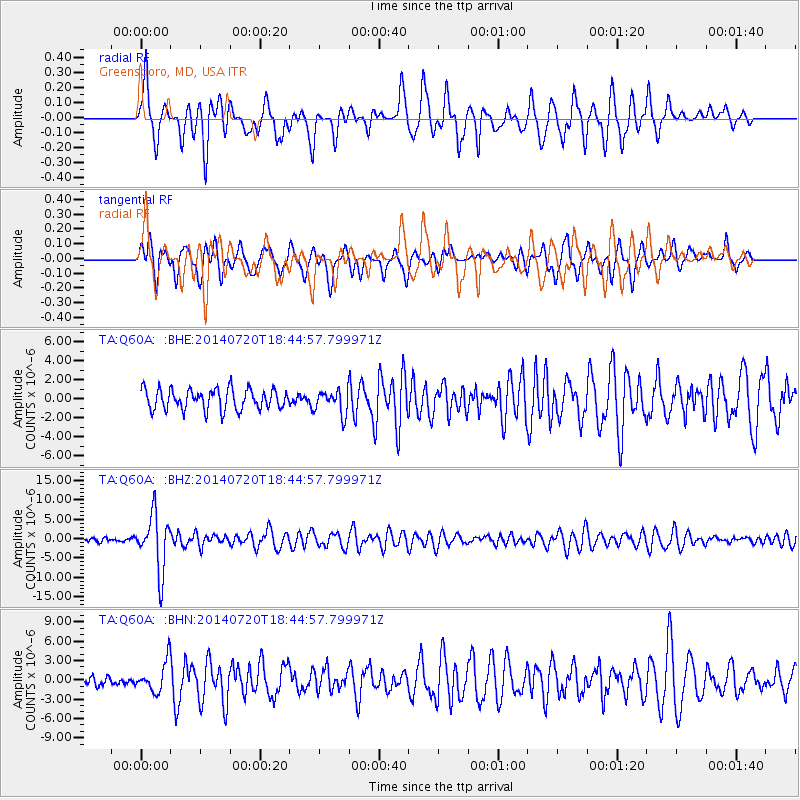
Signal To Noise
| Channel | StoN | STA | LTA |
| TA:Q60A: :BHZ:20140720T18:44:57.799971Z | 8.689323 | 7.351127E-6 | 8.459953E-7 |
| TA:Q60A: :BHN:20140720T18:44:57.799971Z | 3.4990497 | 2.3356577E-6 | 6.6751204E-7 |
| TA:Q60A: :BHE:20140720T18:44:57.799971Z | 1.1813965 | 1.2660572E-6 | 1.0716616E-6 |
| Arrivals |
| Ps | 7.7 SECOND |
| PpPs | 21 SECOND |
| PsPs/PpSs | 29 SECOND |


