You are here: Home > Network List > TA - USArray Transportable Network (new EarthScope stations) Stations List
> Station S53A Williamson, WV, USA > Earthquake Result Viewer
S53A Williamson, WV, USA - Earthquake Result Viewer

| Earthquake location: |
Kuril Islands |
| Earthquake latitude/longitude: |
44.6/148.7 |
| Earthquake time(UTC): |
2014/07/20 (201) 18:32:47 GMT |
| Earthquake Depth: |
61 km |
| Earthquake Magnitude: |
6.6 MB |
| Earthquake Catalog/Contributor: |
NEIC PDE/NEIC COMCAT |
|
| Network: |
TA USArray Transportable Network (new EarthScope stations) |
| Station: |
S53A Williamson, WV, USA |
| Lat/Lon: |
37.68 N/82.13 W |
| Elevation: |
564 m |
|
| Distance: |
86.1 deg |
| Az: |
38.08 deg |
| Baz: |
326.283 deg |
| Ray Param: |
0.044201255 |
| Estimated Moho Depth: |
45.0 km |
| Estimated Crust Vp/Vs: |
1.85 |
| Assumed Crust Vp: |
6.476 km/s |
| Estimated Crust Vs: |
3.496 km/s |
| Estimated Crust Poisson's Ratio: |
0.29 |
|
| Radial Match: |
90.733505 % |
| Radial Bump: |
400 |
| Transverse Match: |
85.359825 % |
| Transverse Bump: |
400 |
| SOD ConfigId: |
751272 |
| Insert Time: |
2014-08-04 16:23:22.351 +0000 |
| GWidth: |
2.5 |
| Max Bumps: |
400 |
| Tol: |
0.001 |
|
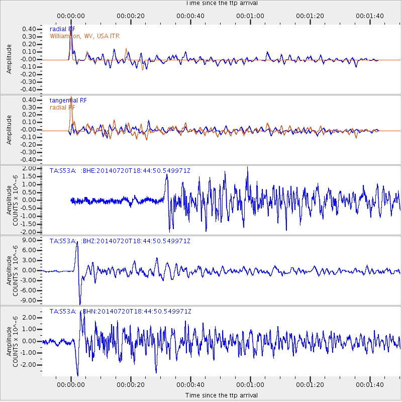
Signal To Noise
| Channel | StoN | STA | LTA |
| TA:S53A: :BHZ:20140720T18:44:50.549971Z | 48.898746 | 4.426747E-6 | 9.052884E-8 |
| TA:S53A: :BHN:20140720T18:44:50.549971Z | 10.327651 | 1.316103E-6 | 1.2743489E-7 |
| TA:S53A: :BHE:20140720T18:44:50.549971Z | 7.820768 | 8.59377E-7 | 1.0988396E-7 |
| Arrivals |
| Ps | 6.1 SECOND |
| PpPs | 19 SECOND |
| PsPs/PpSs | 25 SECOND |


