You are here: Home > Network List > TA - USArray Transportable Network (new EarthScope stations) Stations List
> Station S60A Water View, VA, USA > Earthquake Result Viewer
S60A Water View, VA, USA - Earthquake Result Viewer
| Earthquake location: |
Kuril Islands |
| Earthquake latitude/longitude: |
44.6/148.7 |
| Earthquake time(UTC): |
2014/07/20 (201) 18:32:47 GMT |
| Earthquake Depth: |
61 km |
| Earthquake Magnitude: |
6.6 MB |
| Earthquake Catalog/Contributor: |
NEIC PDE/NEIC COMCAT |
|
| Network: |
TA USArray Transportable Network (new EarthScope stations) |
| Station: |
S60A Water View, VA, USA |
| Lat/Lon: |
37.42 N/76.39 W |
| Elevation: |
36 m |
|
| Distance: |
88.7 deg |
| Az: |
34.352 deg |
| Baz: |
329.595 deg |
| Ray Param: |
0.04227299 |
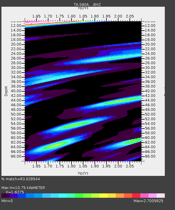
| Estimated Moho Depth: |
10.75 km |
| Estimated Crust Vp/Vs: |
1.63 |
| Assumed Crust Vp: |
6.565 km/s |
| Estimated Crust Vs: |
4.033 km/s |
| Estimated Crust Poisson's Ratio: |
0.20 |
|
| Radial Match: |
93.829544 % |
| Radial Bump: |
400 |
| Transverse Match: |
85.459076 % |
| Transverse Bump: |
400 |
| SOD ConfigId: |
751272 |
| Insert Time: |
2014-08-04 16:23:49.300 +0000 |
| GWidth: |
2.5 |
| Max Bumps: |
400 |
| Tol: |
0.001 |
|

Signal To Noise
| Channel | StoN | STA | LTA |
| TA:S60A: :BHZ:20140720T18:45:01.574995Z | 22.83608 | 5.783817E-6 | 2.5327537E-7 |
| TA:S60A: :BHN:20140720T18:45:01.574995Z | 7.9461956 | 4.340719E-6 | 5.462638E-7 |
| TA:S60A: :BHE:20140720T18:45:01.574995Z | 4.4415865 | 2.2207144E-6 | 4.9998226E-7 |
| Arrivals |
| Ps | 1.1 SECOND |
| PpPs | 4.2 SECOND |
| PsPs/PpSs | 5.3 SECOND |


