You are here: Home > Network List > II - Global Seismograph Network (GSN - IRIS/IDA) Stations List
> Station NIL Nilore, Pakistan > Earthquake Result Viewer
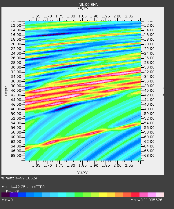
NIL Nilore, Pakistan - Earthquake Result Viewer
| Earthquake location: |
Queen Charlotte Islands Region |
| Earthquake latitude/longitude: |
51.3/-130.4 |
| Earthquake time(UTC): |
2008/01/05 (005) 10:39:14 GMT |
| Earthquake Depth: |
10 km |
| Earthquake Magnitude: |
5.6 MW, 5.2 MB, 5.6 MW |
| Earthquake Catalog/Contributor: |
WHDF/NEIC |
|
| Network: |
II Global Seismograph Network (GSN - IRIS/IDA) |
| Station: |
NIL Nilore, Pakistan |
| Lat/Lon: |
33.65 N/73.27 E |
| Elevation: |
629 m |
|
| Distance: |
92.9 deg |
| Az: |
340.418 deg |
| Baz: |
14.602 deg |
| Ray Param: |
0.041374363 |
| Estimated Moho Depth: |
42.25 km |
| Estimated Crust Vp/Vs: |
1.79 |
| Assumed Crust Vp: |
6.242 km/s |
| Estimated Crust Vs: |
3.487 km/s |
| Estimated Crust Poisson's Ratio: |
0.27 |
|
| Radial Match: |
99.16524 % |
| Radial Bump: |
58 |
| Transverse Match: |
98.78959 % |
| Transverse Bump: |
63 |
| SOD ConfigId: |
2564 |
| Insert Time: |
2010-03-02 00:23:13.437 +0000 |
| GWidth: |
2.5 |
| Max Bumps: |
400 |
| Tol: |
0.001 |
|

Signal To Noise
| Channel | StoN | STA | LTA |
| II:NIL:00:BHN:20080105T10:51:55.553Z | 0.9093496 | 2.4376752E-7 | 2.68068E-7 |
| II:NIL:00:BHE:20080105T10:51:55.553Z | 0.8299096 | 1.0181494E-7 | 1.2268197E-7 |
| II:NIL:00:BHZ:20080105T10:51:55.553Z | 0.8661974 | 4.460445E-8 | 5.1494553E-8 |
| Arrivals |
| Ps | 5.5 SECOND |
| PpPs | 19 SECOND |
| PsPs/PpSs | 24 SECOND |


