You are here: Home > Network List > TA - USArray Transportable Network (new EarthScope stations) Stations List
> Station T58A Grand View Acres, VA, USA > Earthquake Result Viewer
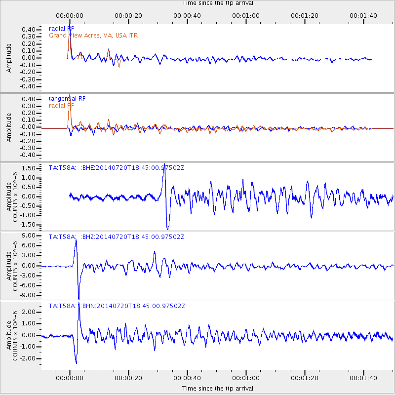
T58A Grand View Acres, VA, USA - Earthquake Result Viewer

| Earthquake location: |
Kuril Islands |
| Earthquake latitude/longitude: |
44.6/148.7 |
| Earthquake time(UTC): |
2014/07/20 (201) 18:32:47 GMT |
| Earthquake Depth: |
61 km |
| Earthquake Magnitude: |
6.6 MB |
| Earthquake Catalog/Contributor: |
NEIC PDE/NEIC COMCAT |
|
| Network: |
TA USArray Transportable Network (new EarthScope stations) |
| Station: |
T58A Grand View Acres, VA, USA |
| Lat/Lon: |
36.95 N/78.53 W |
| Elevation: |
167 m |
|
| Distance: |
88.2 deg |
| Az: |
36.064 deg |
| Baz: |
328.352 deg |
| Ray Param: |
0.042624827 |
| Estimated Moho Depth: |
32.0 km |
| Estimated Crust Vp/Vs: |
1.72 |
| Assumed Crust Vp: |
6.419 km/s |
| Estimated Crust Vs: |
3.727 km/s |
| Estimated Crust Poisson's Ratio: |
0.25 |
|
| Radial Match: |
95.96054 % |
| Radial Bump: |
356 |
| Transverse Match: |
89.17968 % |
| Transverse Bump: |
400 |
| SOD ConfigId: |
751272 |
| Insert Time: |
2014-08-04 16:24:39.126 +0000 |
| GWidth: |
2.5 |
| Max Bumps: |
400 |
| Tol: |
0.001 |
|
Signal To Noise
| Channel | StoN | STA | LTA |
| TA:T58A: :BHZ:20140720T18:45:00.97502Z | 41.241203 | 4.1487287E-6 | 1.00596694E-7 |
| TA:T58A: :BHN:20140720T18:45:00.97502Z | 18.029432 | 1.182085E-6 | 6.556418E-8 |
| TA:T58A: :BHE:20140720T18:45:00.97502Z | 12.055322 | 9.359571E-7 | 7.76385E-8 |
| Arrivals |
| Ps | 3.7 SECOND |
| PpPs | 13 SECOND |
| PsPs/PpSs | 17 SECOND |


