You are here: Home > Network List > TA - USArray Transportable Network (new EarthScope stations) Stations List
> Station U61A Possum Corner Farms, Belvidere, NC, USA > Earthquake Result Viewer
U61A Possum Corner Farms, Belvidere, NC, USA - Earthquake Result Viewer
| Earthquake location: |
Kuril Islands |
| Earthquake latitude/longitude: |
44.6/148.7 |
| Earthquake time(UTC): |
2014/07/20 (201) 18:32:47 GMT |
| Earthquake Depth: |
61 km |
| Earthquake Magnitude: |
6.6 MB |
| Earthquake Catalog/Contributor: |
NEIC PDE/NEIC COMCAT |
|
| Network: |
TA USArray Transportable Network (new EarthScope stations) |
| Station: |
U61A Possum Corner Farms, Belvidere, NC, USA |
| Lat/Lon: |
36.33 N/76.45 W |
| Elevation: |
4.0 m |
|
| Distance: |
89.6 deg |
| Az: |
34.941 deg |
| Baz: |
329.571 deg |
| Ray Param: |
0.041720778 |
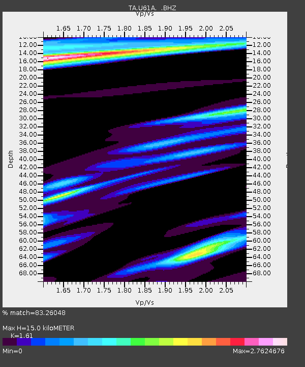
| Estimated Moho Depth: |
15.0 km |
| Estimated Crust Vp/Vs: |
1.61 |
| Assumed Crust Vp: |
6.565 km/s |
| Estimated Crust Vs: |
4.077 km/s |
| Estimated Crust Poisson's Ratio: |
0.19 |
|
| Radial Match: |
83.26048 % |
| Radial Bump: |
313 |
| Transverse Match: |
76.65132 % |
| Transverse Bump: |
379 |
| SOD ConfigId: |
751272 |
| Insert Time: |
2014-08-04 16:25:46.660 +0000 |
| GWidth: |
2.5 |
| Max Bumps: |
400 |
| Tol: |
0.001 |
|

Signal To Noise
| Channel | StoN | STA | LTA |
| TA:U61A: :BHZ:20140720T18:45:07.499983Z | 12.248358 | 6.0798966E-6 | 4.9638464E-7 |
| TA:U61A: :BHN:20140720T18:45:07.499983Z | 4.007952 | 2.6028501E-6 | 6.4942145E-7 |
| TA:U61A: :BHE:20140720T18:45:07.499983Z | 1.3649261 | 1.4228108E-6 | 1.0424087E-6 |
| Arrivals |
| Ps | 1.4 SECOND |
| PpPs | 5.8 SECOND |
| PsPs/PpSs | 7.3 SECOND |


