You are here: Home > Network List > TA - USArray Transportable Network (new EarthScope stations) Stations List
> Station W39A Magazine, AR, USA > Earthquake Result Viewer
W39A Magazine, AR, USA - Earthquake Result Viewer
| Earthquake location: |
Kuril Islands |
| Earthquake latitude/longitude: |
44.6/148.7 |
| Earthquake time(UTC): |
2014/07/20 (201) 18:32:47 GMT |
| Earthquake Depth: |
61 km |
| Earthquake Magnitude: |
6.6 MB |
| Earthquake Catalog/Contributor: |
NEIC PDE/NEIC COMCAT |
|
| Network: |
TA USArray Transportable Network (new EarthScope stations) |
| Station: |
W39A Magazine, AR, USA |
| Lat/Lon: |
35.20 N/93.78 W |
| Elevation: |
162 m |
|
| Distance: |
82.4 deg |
| Az: |
47.133 deg |
| Baz: |
320.281 deg |
| Ray Param: |
0.046779647 |
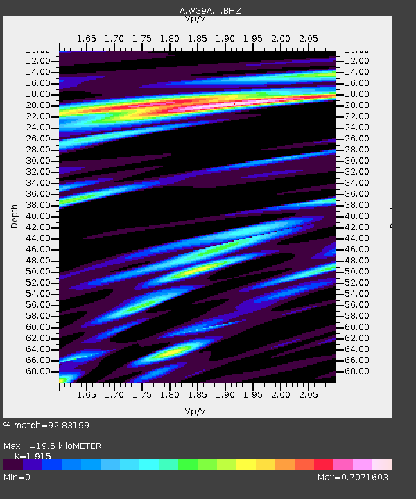
| Estimated Moho Depth: |
19.5 km |
| Estimated Crust Vp/Vs: |
1.91 |
| Assumed Crust Vp: |
6.498 km/s |
| Estimated Crust Vs: |
3.393 km/s |
| Estimated Crust Poisson's Ratio: |
0.31 |
|
| Radial Match: |
92.83199 % |
| Radial Bump: |
400 |
| Transverse Match: |
84.62557 % |
| Transverse Bump: |
400 |
| SOD ConfigId: |
751272 |
| Insert Time: |
2014-08-04 16:26:33.805 +0000 |
| GWidth: |
2.5 |
| Max Bumps: |
400 |
| Tol: |
0.001 |
|

Signal To Noise
| Channel | StoN | STA | LTA |
| TA:W39A: :BHZ:20140720T18:44:32.150007Z | 33.266514 | 3.5537737E-6 | 1.0682735E-7 |
| TA:W39A: :BHN:20140720T18:44:32.150007Z | 12.139964 | 6.4818937E-7 | 5.3393023E-8 |
| TA:W39A: :BHE:20140720T18:44:32.150007Z | 9.699392 | 5.760456E-7 | 5.9389865E-8 |
| Arrivals |
| Ps | 2.8 SECOND |
| PpPs | 8.5 SECOND |
| PsPs/PpSs | 11 SECOND |


