You are here: Home > Network List > TA - USArray Transportable Network (new EarthScope stations) Stations List
> Station X43A Marvell, AR, USA > Earthquake Result Viewer
X43A Marvell, AR, USA - Earthquake Result Viewer
| Earthquake location: |
Kuril Islands |
| Earthquake latitude/longitude: |
44.6/148.7 |
| Earthquake time(UTC): |
2014/07/20 (201) 18:32:47 GMT |
| Earthquake Depth: |
61 km |
| Earthquake Magnitude: |
6.6 MB |
| Earthquake Catalog/Contributor: |
NEIC PDE/NEIC COMCAT |
|
| Network: |
TA USArray Transportable Network (new EarthScope stations) |
| Station: |
X43A Marvell, AR, USA |
| Lat/Lon: |
34.52 N/90.88 W |
| Elevation: |
53 m |
|
| Distance: |
84.5 deg |
| Az: |
45.693 deg |
| Baz: |
321.768 deg |
| Ray Param: |
0.045356117 |
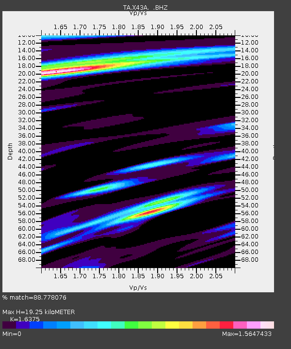
| Estimated Moho Depth: |
19.25 km |
| Estimated Crust Vp/Vs: |
1.64 |
| Assumed Crust Vp: |
6.273 km/s |
| Estimated Crust Vs: |
3.831 km/s |
| Estimated Crust Poisson's Ratio: |
0.20 |
|
| Radial Match: |
88.778076 % |
| Radial Bump: |
400 |
| Transverse Match: |
76.83529 % |
| Transverse Bump: |
400 |
| SOD ConfigId: |
751272 |
| Insert Time: |
2014-08-04 16:27:20.877 +0000 |
| GWidth: |
2.5 |
| Max Bumps: |
400 |
| Tol: |
0.001 |
|

Signal To Noise
| Channel | StoN | STA | LTA |
| TA:X43A: :BHZ:20140720T18:44:42.525007Z | 31.111807 | 5.5059777E-6 | 1.7697388E-7 |
| TA:X43A: :BHN:20140720T18:44:42.525007Z | 3.2248576 | 8.399042E-7 | 2.604469E-7 |
| TA:X43A: :BHE:20140720T18:44:42.525007Z | 1.3897648 | 6.641838E-7 | 4.7791093E-7 |
| Arrivals |
| Ps | 2.0 SECOND |
| PpPs | 7.9 SECOND |
| PsPs/PpSs | 9.9 SECOND |


