You are here: Home > Network List > TA - USArray Transportable Network (new EarthScope stations) Stations List
> Station Y55A Saluda, SC, USA > Earthquake Result Viewer
Y55A Saluda, SC, USA - Earthquake Result Viewer
| Earthquake location: |
Kuril Islands |
| Earthquake latitude/longitude: |
44.6/148.7 |
| Earthquake time(UTC): |
2014/07/20 (201) 18:32:47 GMT |
| Earthquake Depth: |
61 km |
| Earthquake Magnitude: |
6.6 MB |
| Earthquake Catalog/Contributor: |
NEIC PDE/NEIC COMCAT |
|
| Network: |
TA USArray Transportable Network (new EarthScope stations) |
| Station: |
Y55A Saluda, SC, USA |
| Lat/Lon: |
33.94 N/81.86 W |
| Elevation: |
164 m |
|
| Distance: |
89.3 deg |
| Az: |
39.967 deg |
| Baz: |
326.515 deg |
| Ray Param: |
0.041840404 |
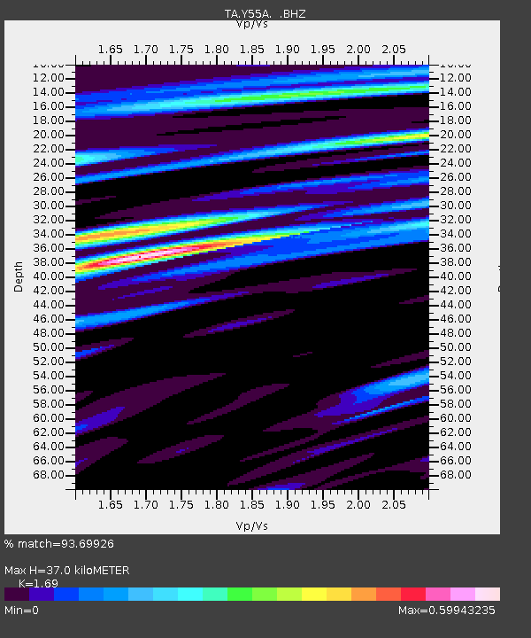
| Estimated Moho Depth: |
37.0 km |
| Estimated Crust Vp/Vs: |
1.69 |
| Assumed Crust Vp: |
6.565 km/s |
| Estimated Crust Vs: |
3.884 km/s |
| Estimated Crust Poisson's Ratio: |
0.23 |
|
| Radial Match: |
93.69926 % |
| Radial Bump: |
400 |
| Transverse Match: |
87.341286 % |
| Transverse Bump: |
400 |
| SOD ConfigId: |
751272 |
| Insert Time: |
2014-08-04 16:27:57.715 +0000 |
| GWidth: |
2.5 |
| Max Bumps: |
400 |
| Tol: |
0.001 |
|
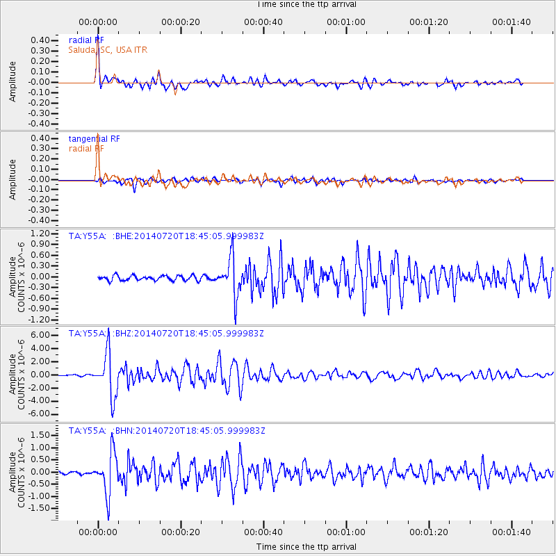
Signal To Noise
| Channel | StoN | STA | LTA |
| TA:Y55A: :BHZ:20140720T18:45:05.999983Z | 46.87666 | 3.4140444E-6 | 7.283037E-8 |
| TA:Y55A: :BHN:20140720T18:45:05.999983Z | 15.128675 | 8.831657E-7 | 5.837693E-8 |
| TA:Y55A: :BHE:20140720T18:45:05.999983Z | 8.16659 | 5.5368366E-7 | 6.779864E-8 |
| Arrivals |
| Ps | 4.0 SECOND |
| PpPs | 15 SECOND |
| PsPs/PpSs | 19 SECOND |


