You are here: Home > Network List > CI - Caltech Regional Seismic Network Stations List
> Station NEE Needles, California, USA > Earthquake Result Viewer
NEE Needles, California, USA - Earthquake Result Viewer
| Earthquake location: |
Kodiak Island Region, Alaska |
| Earthquake latitude/longitude: |
57.4/-154.5 |
| Earthquake time(UTC): |
1999/12/07 (341) 00:19:49 GMT |
| Earthquake Depth: |
41 km |
| Earthquake Magnitude: |
6.5 MB, 6.1 MS, 6.4 MW, 6.3 ML |
| Earthquake Catalog/Contributor: |
WHDF/NEIC |
|
| Network: |
CI Caltech Regional Seismic Network |
| Station: |
NEE Needles, California, USA |
| Lat/Lon: |
34.82 N/114.60 W |
| Elevation: |
139 m |
|
| Distance: |
34.9 deg |
| Az: |
112.834 deg |
| Baz: |
322.622 deg |
| Ray Param: |
0.07739389 |
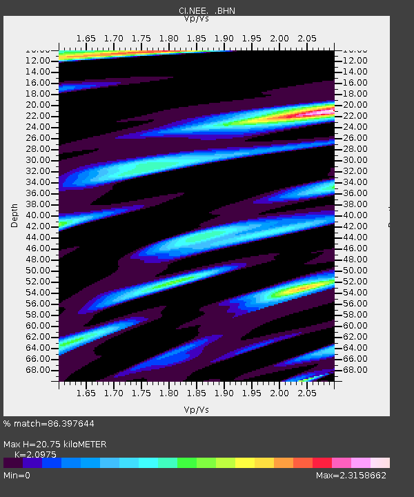
| Estimated Moho Depth: |
20.75 km |
| Estimated Crust Vp/Vs: |
2.10 |
| Assumed Crust Vp: |
6.276 km/s |
| Estimated Crust Vs: |
2.992 km/s |
| Estimated Crust Poisson's Ratio: |
0.35 |
|
| Radial Match: |
86.397644 % |
| Radial Bump: |
400 |
| Transverse Match: |
82.327255 % |
| Transverse Bump: |
400 |
| SOD ConfigId: |
3787 |
| Insert Time: |
2010-02-25 21:12:45.417 +0000 |
| GWidth: |
2.5 |
| Max Bumps: |
400 |
| Tol: |
0.001 |
|
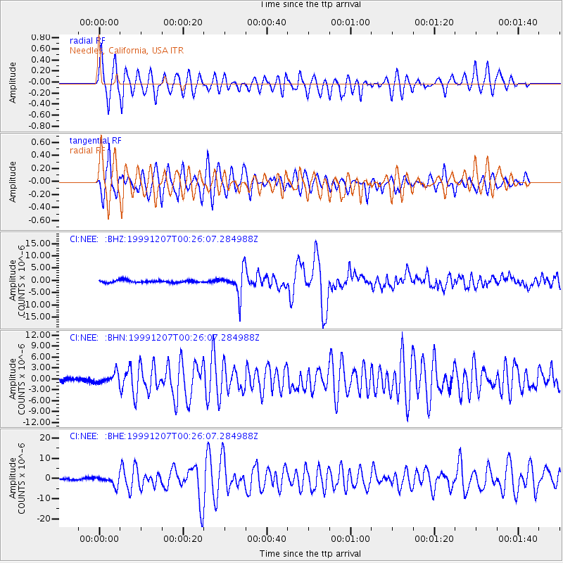
Signal To Noise
| Channel | StoN | STA | LTA |
| CI:NEE: :BHN:19991207T00:26:07.284988Z | 2.3810008 | 1.4667346E-6 | 6.16016E-7 |
| CI:NEE: :BHE:19991207T00:26:07.284988Z | 2.3023527 | 2.418228E-6 | 1.050329E-6 |
| CI:NEE: :BHZ:19991207T00:26:07.284988Z | 10.506427 | 5.166531E-6 | 4.917496E-7 |
| Arrivals |
| Ps | 3.9 SECOND |
| PpPs | 9.6 SECOND |
| PsPs/PpSs | 13 SECOND |


