You are here: Home > Network List > US - United States National Seismic Network Stations List
> Station ACSO Alum Creek State Park, Ohio, USA > Earthquake Result Viewer
ACSO Alum Creek State Park, Ohio, USA - Earthquake Result Viewer
| Earthquake location: |
Kuril Islands |
| Earthquake latitude/longitude: |
44.6/148.7 |
| Earthquake time(UTC): |
2014/07/20 (201) 18:32:47 GMT |
| Earthquake Depth: |
61 km |
| Earthquake Magnitude: |
6.6 MB |
| Earthquake Catalog/Contributor: |
NEIC PDE/NEIC COMCAT |
|
| Network: |
US United States National Seismic Network |
| Station: |
ACSO Alum Creek State Park, Ohio, USA |
| Lat/Lon: |
40.23 N/82.98 W |
| Elevation: |
288 m |
|
| Distance: |
83.6 deg |
| Az: |
37.205 deg |
| Baz: |
325.668 deg |
| Ray Param: |
0.045965567 |
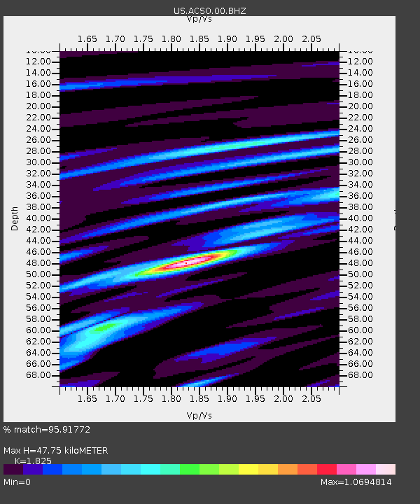
| Estimated Moho Depth: |
47.75 km |
| Estimated Crust Vp/Vs: |
1.83 |
| Assumed Crust Vp: |
6.498 km/s |
| Estimated Crust Vs: |
3.56 km/s |
| Estimated Crust Poisson's Ratio: |
0.29 |
|
| Radial Match: |
95.91772 % |
| Radial Bump: |
400 |
| Transverse Match: |
91.24969 % |
| Transverse Bump: |
400 |
| SOD ConfigId: |
751272 |
| Insert Time: |
2014-08-04 16:30:33.463 +0000 |
| GWidth: |
2.5 |
| Max Bumps: |
400 |
| Tol: |
0.001 |
|
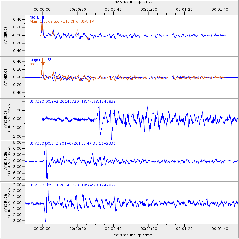
Signal To Noise
| Channel | StoN | STA | LTA |
| US:ACSO:00:BHZ:20140720T18:44:38.124983Z | 55.81925 | 4.3969553E-6 | 7.8771315E-8 |
| US:ACSO:00:BH1:20140720T18:44:38.124983Z | 18.969687 | 1.5345986E-6 | 8.0897415E-8 |
| US:ACSO:00:BH2:20140720T18:44:38.124983Z | 8.443409 | 8.518923E-7 | 1.0089435E-7 |
| Arrivals |
| Ps | 6.2 SECOND |
| PpPs | 20 SECOND |
| PsPs/PpSs | 26 SECOND |


