You are here: Home > Network List > US - United States National Seismic Network Stations List
> Station EYMN Ely, Minnesota, USA > Earthquake Result Viewer
EYMN Ely, Minnesota, USA - Earthquake Result Viewer
| Earthquake location: |
Kuril Islands |
| Earthquake latitude/longitude: |
44.6/148.7 |
| Earthquake time(UTC): |
2014/07/20 (201) 18:32:47 GMT |
| Earthquake Depth: |
61 km |
| Earthquake Magnitude: |
6.6 MB |
| Earthquake Catalog/Contributor: |
NEIC PDE/NEIC COMCAT |
|
| Network: |
US United States National Seismic Network |
| Station: |
EYMN Ely, Minnesota, USA |
| Lat/Lon: |
47.95 N/91.50 W |
| Elevation: |
475 m |
|
| Distance: |
73.7 deg |
| Az: |
37.432 deg |
| Baz: |
319.791 deg |
| Ray Param: |
0.05266919 |
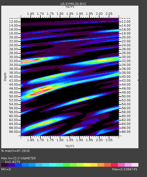
| Estimated Moho Depth: |
32.0 km |
| Estimated Crust Vp/Vs: |
1.63 |
| Assumed Crust Vp: |
6.467 km/s |
| Estimated Crust Vs: |
3.973 km/s |
| Estimated Crust Poisson's Ratio: |
0.20 |
|
| Radial Match: |
97.2928 % |
| Radial Bump: |
324 |
| Transverse Match: |
91.71736 % |
| Transverse Bump: |
400 |
| SOD ConfigId: |
751272 |
| Insert Time: |
2014-08-04 16:32:23.606 +0000 |
| GWidth: |
2.5 |
| Max Bumps: |
400 |
| Tol: |
0.001 |
|
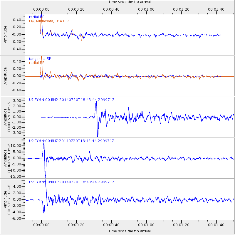
Signal To Noise
| Channel | StoN | STA | LTA |
| US:EYMN:00:BHZ:20140720T18:43:44.299971Z | 78.25283 | 6.355914E-6 | 8.12228E-8 |
| US:EYMN:00:BH1:20140720T18:43:44.299971Z | 29.99116 | 2.3250811E-6 | 7.752554E-8 |
| US:EYMN:00:BH2:20140720T18:43:44.299971Z | 30.448317 | 1.5927977E-6 | 5.231152E-8 |
| Arrivals |
| Ps | 3.2 SECOND |
| PpPs | 13 SECOND |
| PsPs/PpSs | 16 SECOND |


