You are here: Home > Network List > US - United States National Seismic Network Stations List
> Station MCWV Mont Chateau, West Virginia, USA > Earthquake Result Viewer
MCWV Mont Chateau, West Virginia, USA - Earthquake Result Viewer

| Earthquake location: |
Kuril Islands |
| Earthquake latitude/longitude: |
44.6/148.7 |
| Earthquake time(UTC): |
2014/07/20 (201) 18:32:47 GMT |
| Earthquake Depth: |
61 km |
| Earthquake Magnitude: |
6.6 MB |
| Earthquake Catalog/Contributor: |
NEIC PDE/NEIC COMCAT |
|
| Network: |
US United States National Seismic Network |
| Station: |
MCWV Mont Chateau, West Virginia, USA |
| Lat/Lon: |
39.66 N/79.85 W |
| Elevation: |
280 m |
|
| Distance: |
85.4 deg |
| Az: |
35.5 deg |
| Baz: |
327.51 deg |
| Ray Param: |
0.044682894 |
| Estimated Moho Depth: |
26.75 km |
| Estimated Crust Vp/Vs: |
1.60 |
| Assumed Crust Vp: |
6.159 km/s |
| Estimated Crust Vs: |
3.849 km/s |
| Estimated Crust Poisson's Ratio: |
0.18 |
|
| Radial Match: |
94.854195 % |
| Radial Bump: |
400 |
| Transverse Match: |
87.48325 % |
| Transverse Bump: |
400 |
| SOD ConfigId: |
751272 |
| Insert Time: |
2014-08-04 16:33:55.685 +0000 |
| GWidth: |
2.5 |
| Max Bumps: |
400 |
| Tol: |
0.001 |
|
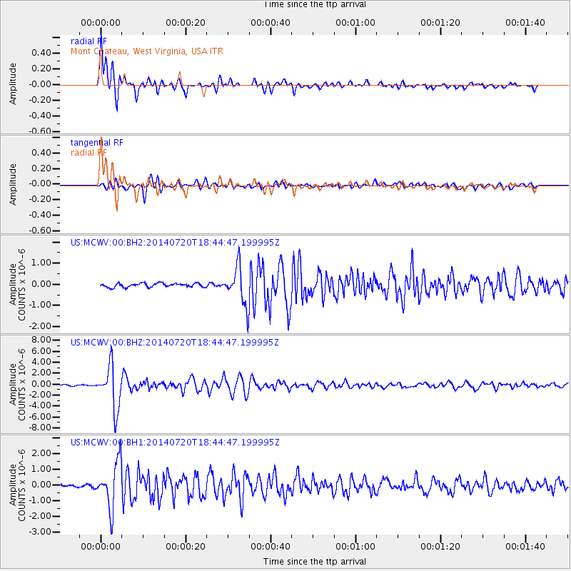
Signal To Noise
| Channel | StoN | STA | LTA |
| US:MCWV:00:BHZ:20140720T18:44:47.199995Z | 44.469414 | 3.991916E-6 | 8.976768E-8 |
| US:MCWV:00:BH1:20140720T18:44:47.199995Z | 19.47201 | 1.499113E-6 | 7.6988094E-8 |
| US:MCWV:00:BH2:20140720T18:44:47.199995Z | 10.420815 | 9.249548E-7 | 8.876031E-8 |
| Arrivals |
| Ps | 2.7 SECOND |
| PpPs | 11 SECOND |
| PsPs/PpSs | 14 SECOND |


