You are here: Home > Network List > US - United States National Seismic Network Stations List
> Station WUAZ Wupatki, Arizona, USA > Earthquake Result Viewer
WUAZ Wupatki, Arizona, USA - Earthquake Result Viewer
| Earthquake location: |
Kuril Islands |
| Earthquake latitude/longitude: |
44.6/148.7 |
| Earthquake time(UTC): |
2014/07/20 (201) 18:32:47 GMT |
| Earthquake Depth: |
61 km |
| Earthquake Magnitude: |
6.6 MB |
| Earthquake Catalog/Contributor: |
NEIC PDE/NEIC COMCAT |
|
| Network: |
US United States National Seismic Network |
| Station: |
WUAZ Wupatki, Arizona, USA |
| Lat/Lon: |
35.52 N/111.37 W |
| Elevation: |
1592 m |
|
| Distance: |
72.3 deg |
| Az: |
57.541 deg |
| Baz: |
312.39 deg |
| Ray Param: |
0.05365257 |
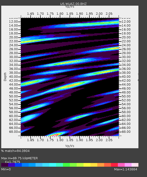
| Estimated Moho Depth: |
69.75 km |
| Estimated Crust Vp/Vs: |
1.77 |
| Assumed Crust Vp: |
6.207 km/s |
| Estimated Crust Vs: |
3.512 km/s |
| Estimated Crust Poisson's Ratio: |
0.26 |
|
| Radial Match: |
94.0904 % |
| Radial Bump: |
400 |
| Transverse Match: |
90.69098 % |
| Transverse Bump: |
400 |
| SOD ConfigId: |
751272 |
| Insert Time: |
2014-08-04 16:35:24.846 +0000 |
| GWidth: |
2.5 |
| Max Bumps: |
400 |
| Tol: |
0.001 |
|
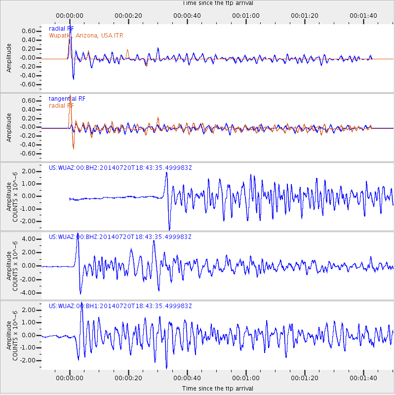
Signal To Noise
| Channel | StoN | STA | LTA |
| US:WUAZ:00:BHZ:20140720T18:43:35.499983Z | 44.661472 | 2.136136E-6 | 4.7829506E-8 |
| US:WUAZ:00:BH1:20140720T18:43:35.499983Z | 17.547012 | 1.0559468E-6 | 6.017815E-8 |
| US:WUAZ:00:BH2:20140720T18:43:35.499983Z | 13.758767 | 1.0559575E-6 | 7.6747966E-8 |
| Arrivals |
| Ps | 8.9 SECOND |
| PpPs | 30 SECOND |
| PsPs/PpSs | 39 SECOND |


