You are here: Home > Network List > UU - University of Utah Regional Network Stations List
> Station NOQ North Oquirrh Mountains, UT, USA > Earthquake Result Viewer
NOQ North Oquirrh Mountains, UT, USA - Earthquake Result Viewer
| Earthquake location: |
Kuril Islands |
| Earthquake latitude/longitude: |
44.6/148.7 |
| Earthquake time(UTC): |
2014/07/20 (201) 18:32:47 GMT |
| Earthquake Depth: |
61 km |
| Earthquake Magnitude: |
6.6 MB |
| Earthquake Catalog/Contributor: |
NEIC PDE/NEIC COMCAT |
|
| Network: |
UU University of Utah Regional Network |
| Station: |
NOQ North Oquirrh Mountains, UT, USA |
| Lat/Lon: |
40.65 N/112.12 W |
| Elevation: |
1622 m |
|
| Distance: |
68.4 deg |
| Az: |
53.882 deg |
| Baz: |
310.698 deg |
| Ray Param: |
0.056186326 |
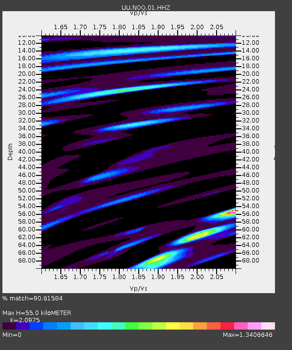
| Estimated Moho Depth: |
55.0 km |
| Estimated Crust Vp/Vs: |
2.10 |
| Assumed Crust Vp: |
6.276 km/s |
| Estimated Crust Vs: |
2.992 km/s |
| Estimated Crust Poisson's Ratio: |
0.35 |
|
| Radial Match: |
90.61584 % |
| Radial Bump: |
400 |
| Transverse Match: |
91.65898 % |
| Transverse Bump: |
400 |
| SOD ConfigId: |
751272 |
| Insert Time: |
2014-08-04 16:36:52.998 +0000 |
| GWidth: |
2.5 |
| Max Bumps: |
400 |
| Tol: |
0.001 |
|

Signal To Noise
| Channel | StoN | STA | LTA |
| UU:NOQ:01:HHZ:20140720T18:43:12.103987Z | 42.077305 | 1.0810552E-7 | 2.569212E-9 |
| UU:NOQ:01:HHN:20140720T18:43:12.103987Z | 11.748428 | 3.6543607E-8 | 3.1105105E-9 |
| UU:NOQ:01:HHE:20140720T18:43:12.103987Z | 10.0472555 | 3.6582186E-8 | 3.6410128E-9 |
| Arrivals |
| Ps | 9.9 SECOND |
| PpPs | 26 SECOND |
| PsPs/PpSs | 36 SECOND |


