You are here: Home > Network List > UU - University of Utah Regional Network Stations List
> Station SZCU Shurtz Canyon, UT, USA > Earthquake Result Viewer
SZCU Shurtz Canyon, UT, USA - Earthquake Result Viewer
| Earthquake location: |
Kuril Islands |
| Earthquake latitude/longitude: |
44.6/148.7 |
| Earthquake time(UTC): |
2014/07/20 (201) 18:32:47 GMT |
| Earthquake Depth: |
61 km |
| Earthquake Magnitude: |
6.6 MB |
| Earthquake Catalog/Contributor: |
NEIC PDE/NEIC COMCAT |
|
| Network: |
UU University of Utah Regional Network |
| Station: |
SZCU Shurtz Canyon, UT, USA |
| Lat/Lon: |
37.60 N/113.09 W |
| Elevation: |
2026 m |
|
| Distance: |
69.8 deg |
| Az: |
56.878 deg |
| Baz: |
311.158 deg |
| Ray Param: |
0.055243414 |
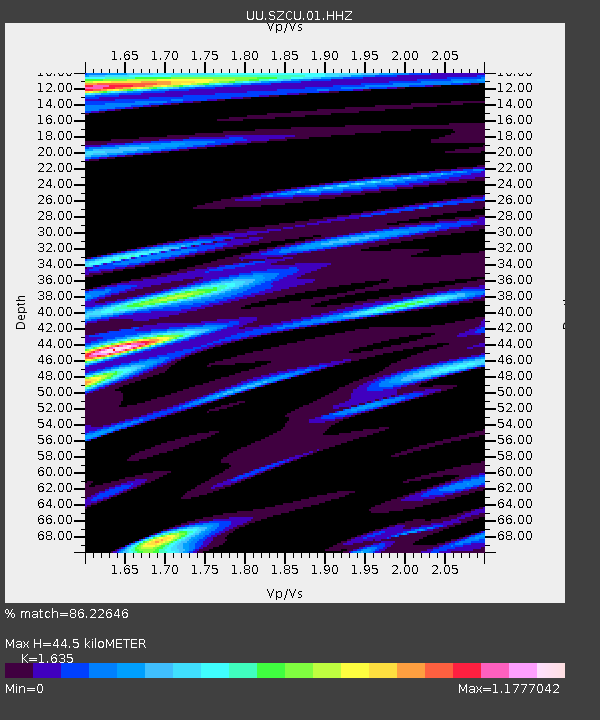
| Estimated Moho Depth: |
44.5 km |
| Estimated Crust Vp/Vs: |
1.63 |
| Assumed Crust Vp: |
6.194 km/s |
| Estimated Crust Vs: |
3.789 km/s |
| Estimated Crust Poisson's Ratio: |
0.20 |
|
| Radial Match: |
86.22646 % |
| Radial Bump: |
400 |
| Transverse Match: |
83.38561 % |
| Transverse Bump: |
400 |
| SOD ConfigId: |
751272 |
| Insert Time: |
2014-08-04 16:37:23.747 +0000 |
| GWidth: |
2.5 |
| Max Bumps: |
400 |
| Tol: |
0.001 |
|

Signal To Noise
| Channel | StoN | STA | LTA |
| UU:SZCU:01:HHZ:20140720T18:43:20.939985Z | 22.814909 | 5.289854E-8 | 2.3185953E-9 |
| UU:SZCU:01:HHN:20140720T18:43:20.939985Z | 6.5258775 | 1.3521507E-8 | 2.071983E-9 |
| UU:SZCU:01:HHE:20140720T18:43:20.939985Z | 5.6622033 | 1.3249792E-8 | 2.3400417E-9 |
| Arrivals |
| Ps | 4.7 SECOND |
| PpPs | 18 SECOND |
| PsPs/PpSs | 23 SECOND |


