You are here: Home > Network List > UW - Pacific Northwest Regional Seismic Network Stations List
> Station FISH Seaside, OR, USA > Earthquake Result Viewer
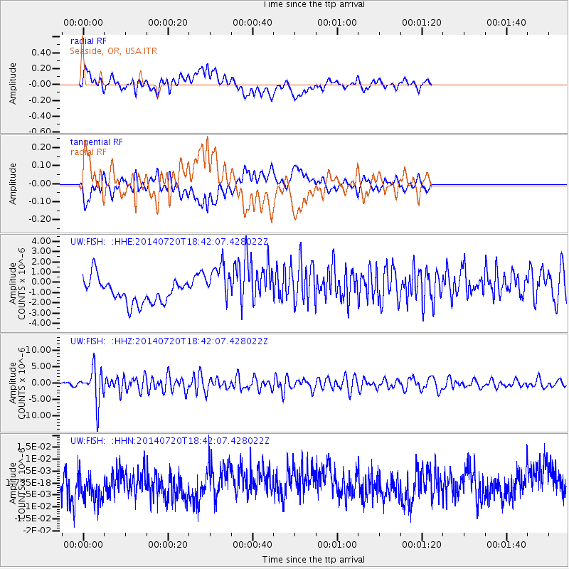
FISH Seaside, OR, USA - Earthquake Result Viewer
*The percent match for this event was below the threshold and hence no stack was calculated.
| Earthquake location: |
Kuril Islands |
| Earthquake latitude/longitude: |
44.6/148.7 |
| Earthquake time(UTC): |
2014/07/20 (201) 18:32:47 GMT |
| Earthquake Depth: |
61 km |
| Earthquake Magnitude: |
6.6 MB |
| Earthquake Catalog/Contributor: |
NEIC PDE/NEIC COMCAT |
|
| Network: |
UW Pacific Northwest Regional Seismic Network |
| Station: |
FISH Seaside, OR, USA |
| Lat/Lon: |
45.93 N/123.56 W |
| Elevation: |
325 m |
|
| Distance: |
58.6 deg |
| Az: |
54.803 deg |
| Baz: |
303.273 deg |
| Ray Param: |
$rayparam |
*The percent match for this event was below the threshold and hence was not used in the summary stack. |
|
| Radial Match: |
46.239025 % |
| Radial Bump: |
400 |
| Transverse Match: |
46.202747 % |
| Transverse Bump: |
400 |
| SOD ConfigId: |
751272 |
| Insert Time: |
2014-08-04 16:38:27.648 +0000 |
| GWidth: |
2.5 |
| Max Bumps: |
400 |
| Tol: |
0.001 |
|
Signal To Noise
| Channel | StoN | STA | LTA |
| UW:FISH: :HHZ:20140720T18:42:07.428022Z | 7.6703167 | 5.1163584E-6 | 6.670335E-7 |
| UW:FISH: :HHN:20140720T18:42:07.428022Z | 1.1345059 | 6.5940617E-9 | 5.8122764E-9 |
| UW:FISH: :HHE:20140720T18:42:07.428022Z | 1.8018485 | 2.0454786E-6 | 1.135211E-6 |
| Arrivals |
| Ps | |
| PpPs | |
| PsPs/PpSs | |


