You are here: Home > Network List > WU - The Southern Ontario Seismic Network Stations List
> Station BMRO Meriville Lake, Ontario, Canada > Earthquake Result Viewer
BMRO Meriville Lake, Ontario, Canada - Earthquake Result Viewer
| Earthquake location: |
Kuril Islands |
| Earthquake latitude/longitude: |
44.6/148.7 |
| Earthquake time(UTC): |
2014/07/20 (201) 18:32:47 GMT |
| Earthquake Depth: |
61 km |
| Earthquake Magnitude: |
6.6 MB |
| Earthquake Catalog/Contributor: |
NEIC PDE/NEIC COMCAT |
|
| Network: |
WU The Southern Ontario Seismic Network |
| Station: |
BMRO Meriville Lake, Ontario, Canada |
| Lat/Lon: |
44.60 N/81.22 W |
| Elevation: |
217 m |
|
| Distance: |
80.7 deg |
| Az: |
33.651 deg |
| Baz: |
326.369 deg |
| Ray Param: |
0.047981847 |
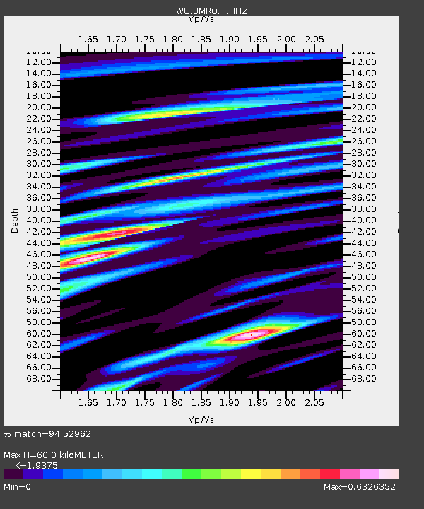
| Estimated Moho Depth: |
60.0 km |
| Estimated Crust Vp/Vs: |
1.94 |
| Assumed Crust Vp: |
6.53 km/s |
| Estimated Crust Vs: |
3.371 km/s |
| Estimated Crust Poisson's Ratio: |
0.32 |
|
| Radial Match: |
94.52962 % |
| Radial Bump: |
335 |
| Transverse Match: |
83.812645 % |
| Transverse Bump: |
400 |
| SOD ConfigId: |
751272 |
| Insert Time: |
2014-08-04 16:41:16.084 +0000 |
| GWidth: |
2.5 |
| Max Bumps: |
400 |
| Tol: |
0.001 |
|

Signal To Noise
| Channel | StoN | STA | LTA |
| WU:BMRO: :HHZ:20140720T18:44:23.09001Z | 46.258293 | 4.954381E-6 | 1.07102544E-7 |
| WU:BMRO: :HHN:20140720T18:44:23.09001Z | 16.968328 | 1.7909208E-6 | 1.0554492E-7 |
| WU:BMRO: :HHE:20140720T18:44:23.09001Z | 14.505326 | 1.3849651E-6 | 9.547976E-8 |
| Arrivals |
| Ps | 8.8 SECOND |
| PpPs | 26 SECOND |
| PsPs/PpSs | 35 SECOND |


