You are here: Home > Network List > Y506 - Canadian Rockies and Alberta Network Stations List
> Station PER CRANE station near Peers AB > Earthquake Result Viewer
PER CRANE station near Peers AB - Earthquake Result Viewer
| Earthquake location: |
Kuril Islands |
| Earthquake latitude/longitude: |
44.6/148.7 |
| Earthquake time(UTC): |
2014/07/20 (201) 18:32:47 GMT |
| Earthquake Depth: |
61 km |
| Earthquake Magnitude: |
6.6 MB |
| Earthquake Catalog/Contributor: |
NEIC PDE/NEIC COMCAT |
|
| Network: |
Y5 Canadian Rockies and Alberta Network |
| Station: |
PER CRANE station near Peers AB |
| Lat/Lon: |
53.68 N/116.04 W |
| Elevation: |
849 m |
|
| Distance: |
58.4 deg |
| Az: |
44.068 deg |
| Baz: |
303.393 deg |
| Ray Param: |
0.062718816 |
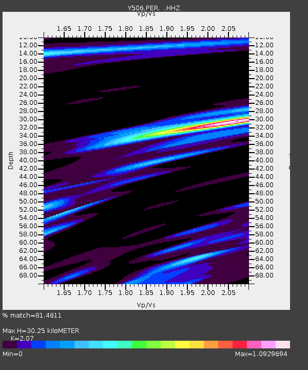
| Estimated Moho Depth: |
30.25 km |
| Estimated Crust Vp/Vs: |
2.07 |
| Assumed Crust Vp: |
6.142 km/s |
| Estimated Crust Vs: |
2.967 km/s |
| Estimated Crust Poisson's Ratio: |
0.35 |
|
| Radial Match: |
81.4611 % |
| Radial Bump: |
400 |
| Transverse Match: |
71.771416 % |
| Transverse Bump: |
400 |
| SOD ConfigId: |
751272 |
| Insert Time: |
2014-08-04 16:43:36.278 +0000 |
| GWidth: |
2.5 |
| Max Bumps: |
400 |
| Tol: |
0.001 |
|

Signal To Noise
| Channel | StoN | STA | LTA |
| Y5:PER: :HHZ:20140720T18:42:06.129988Z | 50.583298 | 7.448057E-6 | 1.4724341E-7 |
| Y5:PER: :HHN:20140720T18:42:06.129988Z | 6.439659 | 1.4952703E-6 | 2.3219712E-7 |
| Y5:PER: :HHE:20140720T18:42:06.129988Z | 5.811384 | 1.8942615E-6 | 3.2595702E-7 |
| Arrivals |
| Ps | 5.5 SECOND |
| PpPs | 15 SECOND |
| PsPs/PpSs | 20 SECOND |


