You are here: Home > Network List > II - Global Seismograph Network (GSN - IRIS/IDA) Stations List
> Station NIL Nilore, Pakistan > Earthquake Result Viewer
NIL Nilore, Pakistan - Earthquake Result Viewer

| Earthquake location: |
Mariana Islands |
| Earthquake latitude/longitude: |
18.9/145.0 |
| Earthquake time(UTC): |
1995/08/24 (236) 01:55:34 GMT |
| Earthquake Depth: |
589 km |
| Earthquake Magnitude: |
5.9 MB, 6.2 UNKNOWN, 6.2 MW |
| Earthquake Catalog/Contributor: |
WHDF/NEIC |
|
| Network: |
II Global Seismograph Network (GSN - IRIS/IDA) |
| Station: |
NIL Nilore, Pakistan |
| Lat/Lon: |
33.65 N/73.27 E |
| Elevation: |
629 m |
|
| Distance: |
64.8 deg |
| Az: |
298.927 deg |
| Baz: |
83.351 deg |
| Ray Param: |
0.056494568 |
| Estimated Moho Depth: |
64.0 km |
| Estimated Crust Vp/Vs: |
1.88 |
| Assumed Crust Vp: |
6.242 km/s |
| Estimated Crust Vs: |
3.311 km/s |
| Estimated Crust Poisson's Ratio: |
0.30 |
|
| Radial Match: |
89.49891 % |
| Radial Bump: |
400 |
| Transverse Match: |
87.98124 % |
| Transverse Bump: |
400 |
| SOD ConfigId: |
6273 |
| Insert Time: |
2010-03-02 00:24:07.651 +0000 |
| GWidth: |
2.5 |
| Max Bumps: |
400 |
| Tol: |
0.001 |
|
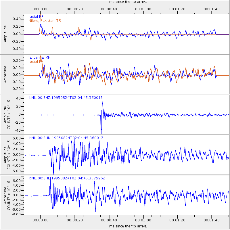
Signal To Noise
| Channel | StoN | STA | LTA |
| II:NIL:00:BHN:19950824T02:04:45.36001Z | 0.8625209 | 6.131629E-8 | 7.108963E-8 |
| II:NIL:00:BHE:19950824T02:04:45.357996Z | 1.1865171 | 1.083814E-7 | 9.134415E-8 |
| II:NIL:00:BHZ:19950824T02:04:45.36001Z | 3.152505 | 3.1615096E-7 | 1.0028564E-7 |
| Arrivals |
| Ps | 9.4 SECOND |
| PpPs | 29 SECOND |
| PsPs/PpSs | 38 SECOND |


