You are here: Home > Network List > YN10 - San Jacinto Fault Zone Stations List
> Station JFS4 JFS4 > Earthquake Result Viewer
JFS4 JFS4 - Earthquake Result Viewer
| Earthquake location: |
Kuril Islands |
| Earthquake latitude/longitude: |
44.6/148.7 |
| Earthquake time(UTC): |
2014/07/20 (201) 18:32:47 GMT |
| Earthquake Depth: |
61 km |
| Earthquake Magnitude: |
6.6 MB |
| Earthquake Catalog/Contributor: |
NEIC PDE/NEIC COMCAT |
|
| Network: |
YN San Jacinto Fault Zone |
| Station: |
JFS4 JFS4 |
| Lat/Lon: |
33.42 N/116.40 W |
| Elevation: |
645 m |
|
| Distance: |
70.5 deg |
| Az: |
62.102 deg |
| Baz: |
311.01 deg |
| Ray Param: |
0.05478346 |
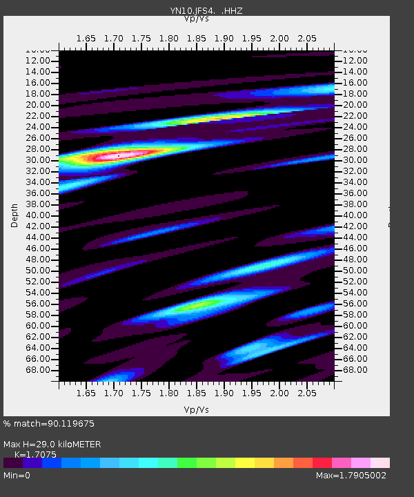
| Estimated Moho Depth: |
29.0 km |
| Estimated Crust Vp/Vs: |
1.71 |
| Assumed Crust Vp: |
6.264 km/s |
| Estimated Crust Vs: |
3.668 km/s |
| Estimated Crust Poisson's Ratio: |
0.24 |
|
| Radial Match: |
90.119675 % |
| Radial Bump: |
400 |
| Transverse Match: |
71.1543 % |
| Transverse Bump: |
400 |
| SOD ConfigId: |
751272 |
| Insert Time: |
2014-08-04 16:44:58.349 +0000 |
| GWidth: |
2.5 |
| Max Bumps: |
400 |
| Tol: |
0.001 |
|

Signal To Noise
| Channel | StoN | STA | LTA |
| YN:JFS4: :HHZ:20140720T18:43:25.184004Z | 41.35153 | 1.7051118E-6 | 4.1234554E-8 |
| YN:JFS4: :HHN:20140720T18:43:25.184004Z | 7.2913246 | 5.8055673E-7 | 7.962294E-8 |
| YN:JFS4: :HHE:20140720T18:43:25.184004Z | 7.8215485 | 7.211684E-7 | 9.220277E-8 |
| Arrivals |
| Ps | 3.4 SECOND |
| PpPs | 12 SECOND |
| PsPs/PpSs | 15 SECOND |


