You are here: Home > Network List > YN10 - San Jacinto Fault Zone Stations List
> Station TR02 TR02 > Earthquake Result Viewer
TR02 TR02 - Earthquake Result Viewer
| Earthquake location: |
Kuril Islands |
| Earthquake latitude/longitude: |
44.6/148.7 |
| Earthquake time(UTC): |
2014/07/20 (201) 18:32:47 GMT |
| Earthquake Depth: |
61 km |
| Earthquake Magnitude: |
6.6 MB |
| Earthquake Catalog/Contributor: |
NEIC PDE/NEIC COMCAT |
|
| Network: |
YN San Jacinto Fault Zone |
| Station: |
TR02 TR02 |
| Lat/Lon: |
33.42 N/116.42 W |
| Elevation: |
770 m |
|
| Distance: |
70.5 deg |
| Az: |
62.114 deg |
| Baz: |
311.007 deg |
| Ray Param: |
0.05478672 |
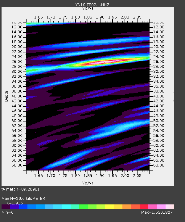
| Estimated Moho Depth: |
26.0 km |
| Estimated Crust Vp/Vs: |
1.91 |
| Assumed Crust Vp: |
6.264 km/s |
| Estimated Crust Vs: |
3.271 km/s |
| Estimated Crust Poisson's Ratio: |
0.31 |
|
| Radial Match: |
89.20981 % |
| Radial Bump: |
400 |
| Transverse Match: |
83.379364 % |
| Transverse Bump: |
400 |
| SOD ConfigId: |
751272 |
| Insert Time: |
2014-08-04 16:45:17.373 +0000 |
| GWidth: |
2.5 |
| Max Bumps: |
400 |
| Tol: |
0.001 |
|

Signal To Noise
| Channel | StoN | STA | LTA |
| YN:TR02: :HHZ:20140720T18:43:25.153975Z | 42.72647 | 1.7887957E-6 | 4.1866215E-8 |
| YN:TR02: :HHN:20140720T18:43:25.153975Z | 5.323689 | 4.199361E-7 | 7.888066E-8 |
| YN:TR02: :HHE:20140720T18:43:25.153975Z | 8.728399 | 9.201648E-7 | 1.0542195E-7 |
| Arrivals |
| Ps | 3.9 SECOND |
| PpPs | 12 SECOND |
| PsPs/PpSs | 16 SECOND |


