You are here: Home > Network List > II - Global Seismograph Network (GSN - IRIS/IDA) Stations List
> Station NIL Nilore, Pakistan > Earthquake Result Viewer
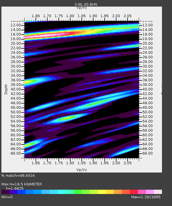
NIL Nilore, Pakistan - Earthquake Result Viewer
| Earthquake location: |
Halmahera, Indonesia |
| Earthquake latitude/longitude: |
1.9/128.5 |
| Earthquake time(UTC): |
1995/05/04 (124) 02:18:51 GMT |
| Earthquake Depth: |
55 km |
| Earthquake Magnitude: |
6.0 MB, 6.0 MS, 6.1 UNKNOWN, 6.1 MW |
| Earthquake Catalog/Contributor: |
WHDF/NEIC |
|
| Network: |
II Global Seismograph Network (GSN - IRIS/IDA) |
| Station: |
NIL Nilore, Pakistan |
| Lat/Lon: |
33.65 N/73.27 E |
| Elevation: |
629 m |
|
| Distance: |
60.4 deg |
| Az: |
308.035 deg |
| Baz: |
109.308 deg |
| Ray Param: |
0.061400376 |
| Estimated Moho Depth: |
16.5 km |
| Estimated Crust Vp/Vs: |
1.66 |
| Assumed Crust Vp: |
6.242 km/s |
| Estimated Crust Vs: |
3.755 km/s |
| Estimated Crust Poisson's Ratio: |
0.22 |
|
| Radial Match: |
89.8434 % |
| Radial Bump: |
400 |
| Transverse Match: |
81.06949 % |
| Transverse Bump: |
400 |
| SOD ConfigId: |
61242 |
| Insert Time: |
2010-03-02 00:24:30.947 +0000 |
| GWidth: |
2.5 |
| Max Bumps: |
400 |
| Tol: |
0.001 |
|

Signal To Noise
| Channel | StoN | STA | LTA |
| II:NIL:00:BHN:19950504T02:28:24.939014Z | 5.208666 | 2.447052E-7 | 4.69804E-8 |
| II:NIL:00:BHE:19950504T02:28:24.937Z | 17.990446 | 8.1736664E-7 | 4.543337E-8 |
| II:NIL:00:BHZ:19950504T02:28:24.939014Z | 54.6576 | 2.90395E-6 | 5.3129845E-8 |
| Arrivals |
| Ps | 1.8 SECOND |
| PpPs | 6.7 SECOND |
| PsPs/PpSs | 8.6 SECOND |


