You are here: Home > Network List > II - Global Seismograph Network (GSN - IRIS/IDA) Stations List
> Station NIL Nilore, Pakistan > Earthquake Result Viewer
NIL Nilore, Pakistan - Earthquake Result Viewer

| Earthquake location: |
Northern Molucca Sea |
| Earthquake latitude/longitude: |
2.6/127.7 |
| Earthquake time(UTC): |
1995/07/26 (207) 23:42:02 GMT |
| Earthquake Depth: |
66 km |
| Earthquake Magnitude: |
5.9 MB, 6.4 UNKNOWN, 6.4 MW |
| Earthquake Catalog/Contributor: |
WHDF/NEIC |
|
| Network: |
II Global Seismograph Network (GSN - IRIS/IDA) |
| Station: |
NIL Nilore, Pakistan |
| Lat/Lon: |
33.65 N/73.27 E |
| Elevation: |
629 m |
|
| Distance: |
59.4 deg |
| Az: |
307.969 deg |
| Baz: |
109.236 deg |
| Ray Param: |
0.062054537 |
| Estimated Moho Depth: |
14.25 km |
| Estimated Crust Vp/Vs: |
1.82 |
| Assumed Crust Vp: |
6.242 km/s |
| Estimated Crust Vs: |
3.434 km/s |
| Estimated Crust Poisson's Ratio: |
0.28 |
|
| Radial Match: |
87.87481 % |
| Radial Bump: |
400 |
| Transverse Match: |
76.140625 % |
| Transverse Bump: |
400 |
| SOD ConfigId: |
61242 |
| Insert Time: |
2010-03-02 00:24:42.647 +0000 |
| GWidth: |
2.5 |
| Max Bumps: |
400 |
| Tol: |
0.001 |
|
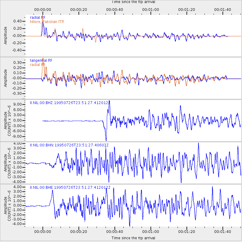
Signal To Noise
| Channel | StoN | STA | LTA |
| II:NIL:00:BHN:19950726T23:51:27.40603Z | 2.245278 | 1.8534524E-7 | 8.2548915E-8 |
| II:NIL:00:BHE:19950726T23:51:27.412012Z | 5.59092 | 4.9320425E-7 | 8.8215224E-8 |
| II:NIL:00:BHZ:19950726T23:51:27.412012Z | 24.682808 | 1.726062E-6 | 6.9929726E-8 |
| Arrivals |
| Ps | 1.9 SECOND |
| PpPs | 6.2 SECOND |
| PsPs/PpSs | 8.1 SECOND |


